Mansehra elevation
Mansehra (Khyber Pakhtunkhwa), Pakistan elevation is 1079 meters and Mansehra elevation in feet is 3540 ft above sea level [src 1]. Mansehra is a seat of a second-order administrative division (feature code) with elevation that is 733 meters (2405 ft) bigger than average city elevation in Pakistan.
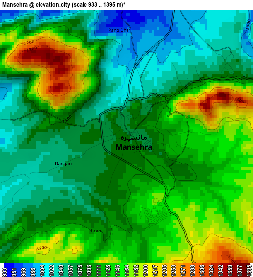
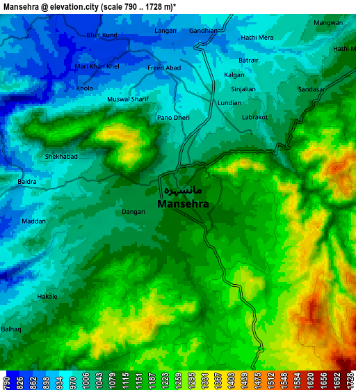
Below is the Elevation map of Mansehra, which displays elevation range with different colors. Scale of the first map is from 933 to 1395 m (3061 to 4577 ft) with average elevation of 1105.8 meters (=3628 ft) [note 1]
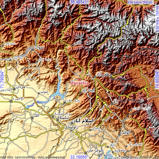
These maps also provides idea of topography and contour of this city, they are displayed at different zoom levels. More info about maps, scale and edge coordinates you can find below images.
| \ | Map #1 | Map #2 | Topo.Map |
| Scale [m] | 933..1395 m | 790..1728 m | × |
| Scale [ft] | 3061..4577 ft | 2592..5669 ft | × |
| Average | 1105.8 m = 3628 ft | 1097.1 m = 3599 ft | × |
| Width | 8.07 km = 5 mi | 16.14 km = 10 mi | 258.2 km = 160.4 mi |
| Height | 8.07 km = 5 mi | 16.14 km = 10 mi | 258.2 km = 160.4 mi |
| ↑Max Latitude | 34.366512° | 34.402779° | 35.48343° |
| Latitude at center | 34.33023° | 34.33023° | 34.33023° |
| ↓Min Latitude | 34.293932° | 34.257618° | 33.16095° |
| ← Min Longitude | 73.152845° | 73.108899° | 71.79054° |
| Longitude center | 73.19679° | 73.19679° | 73.19679° |
| →Max Longitude | 73.240735° | 73.284681° | 74.60304° |
Nearby cities:
Cities around Mansehra sort by population:
• Muzaffarābād elevation 739 m
25.5 km,  80°
80°
• Battagram 1031 m
41.7 km,  337°
337°
• Abbottabad 1241 m
20.5 km,  176°
176°
• Haripur 537 m
44.1 km,  213°
213°
• Havelian 863 m
31 km,  186°
186°
• Khalabat 439 m
41.2 km,  223°
223°
• Topi 348 m
60.3 km,  241°
241°
• Murree 2098 m
50.2 km,  159°
159°
• Baffa 923 m
12.2 km,  11°
11°
• Shingli Bala 1041 m
43.3 km,  333°
333°
• Amirabad 1297 m
18.6 km, 211°
• Hattian Bala 1006 m
53.3 km,  109°
109°
Multilingual:
 En español:
Mansehra elevación 1079 m.
 En France:
Mansehra élévation 1079 m.
 Auf Deutsch:
Mansehra höhe über dem Meeresspiegel ist 1079 m.

Sources and notes:
- [note 1] Map square and city borders are not equal. Map elevation data is calculated only from area inside that square.
- [src 1] Elevation data from geonames database provided with same terms of usage.
- [src 2] The elevation map of Mansehra is generated using elevation data from NASA's 3 arcsec (90m) resolution SRTM data.
- [src 3] Base (background) map © OpenStreetMap contributors tiles are generated by Geofabrik and OpenTopoMap.
Copyright & License:
This Mansehra Elevation Map is licensed under CC BY-SA. You may reuse any part from this page, if you give a proper credit by linking to this URL:
 More info on terms of use page.