Haripur elevation
Haripur (Khyber Pakhtunkhwa), Pakistan elevation is 537 meters and Haripur elevation in feet is 1762 ft above sea level [src 1]. Haripur is a seat of a second-order administrative division (feature code) with elevation that is 191 meters (627 ft) bigger than average city elevation in Pakistan.
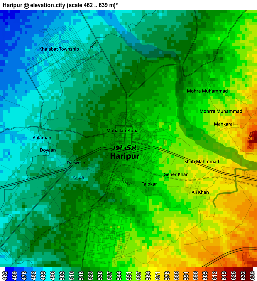
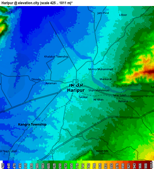
Below is the Elevation map of Haripur, which displays elevation range with different colors. Scale of the first map is from 462 to 639 m (1516 to 2096 ft) with average elevation of 528.9 meters (=1735 ft) [note 1]
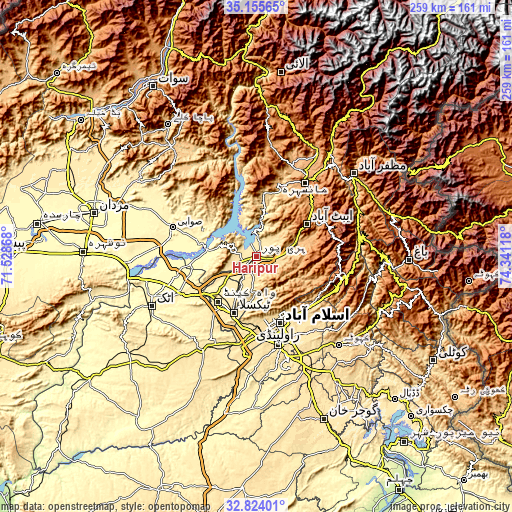
These maps also provides idea of topography and contour of this city, they are displayed at different zoom levels. More info about maps, scale and edge coordinates you can find below images.
| \ | Map #1 | Map #2 | Topo.Map |
| Scale [m] | 462..639 m | 425..1011 m | × |
| Scale [ft] | 1516..2096 ft | 1394..3317 ft | × |
| Average | 528.9 m = 1735 ft | 545.8 m = 1791 ft | × |
| Width | 8.1 km = 5 mi | 16.2 km = 10.1 mi | 259.3 km = 161.1 mi |
| Height | 8.1 km = 5 mi | 16.2 km = 10.1 mi | 259.3 km = 161.1 mi |
| ↑Max Latitude | 34.034255° | 34.070665° | 35.15565° |
| Latitude at center | 33.99783° | 33.99783° | 33.99783° |
| ↓Min Latitude | 33.961389° | 33.924932° | 32.82401° |
| ← Min Longitude | 72.890985° | 72.847039° | 71.52868° |
| Longitude center | 72.93493° | 72.93493° | 72.93493° |
| →Max Longitude | 72.978875° | 73.022821° | 74.34118° |
Nearby cities:
Cities around Haripur sort by population:
• Rawalpindi elevation 499 m
45.7 km,  166°
166°
• Islamabad 579 m
32.3 km,  161°
161°
• Abbottabad 1241 m
30.4 km,  57°
57°
• Swabi 341 m
45 km,  287°
287°
• Mansehra 1079 m
44.1 km,  33°
33°
• Havelian 863 m
21.6 km,  73°
73°
• Khalabat 439 m
8.1 km,  328°
328°
• Topi 348 m
30 km, 285°
• Zaida 320 m
43.7 km,  279°
279°
• Hazro City 320 m
42 km,  256°
256°
• Murree 2098 m
43.2 km,  103°
103°
• Amirabad 1297 m
25.5 km, 34°
Multilingual:
 En español:
Haripur elevación 537 m.
 En France:
Haripur élévation 537 m.


Sources and notes:
- [note 1] Map square and city borders are not equal. Map elevation data is calculated only from area inside that square.
- [src 1] Elevation data from geonames database provided with same terms of usage.
- [src 2] The elevation map of Haripur is generated using elevation data from NASA's 3 arcsec (90m) resolution SRTM data.
- [src 3] Base (background) map © OpenStreetMap contributors tiles are generated by Geofabrik and OpenTopoMap.
Copyright & License:
This Haripur Elevation Map is licensed under CC BY-SA. You may reuse any part from this page, if you give a proper credit by linking to this URL:
 More info on terms of use page.