Barishal elevation
Barishal (Gilgit-Baltistan), Pakistan elevation is 2732 meters and Barishal elevation in feet is 8963 ft above sea level [src 1]. Barishal is a populated place (feature code) with elevation that is 2386 meters (7828 ft) bigger than average city elevation in Pakistan.
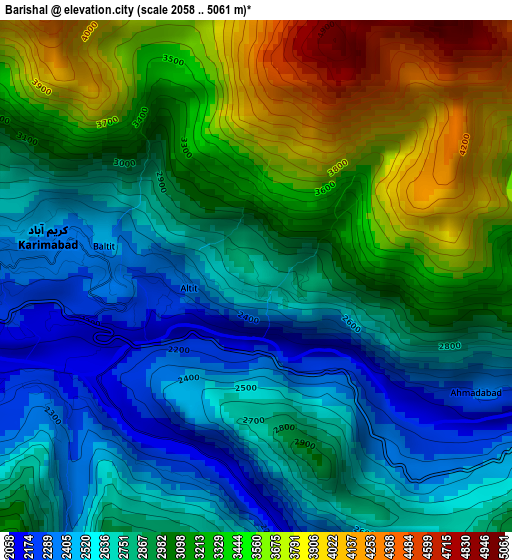
Below is the Elevation map of Barishal, which displays elevation range with different colors. Scale of the first map is from 2058 to 5061 m (6752 to 16604 ft) with average elevation of 3008.8 meters (=9871 ft) [note 1]
These maps also provides idea of topography and contour of this city, they are displayed at different zoom levels. More info about maps, scale and edge coordinates you can find below images.
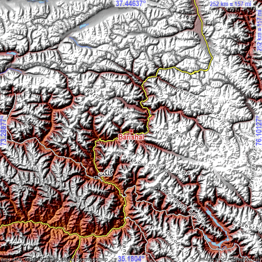
| \ | Map #1 | Topo.Map |
| Scale [m] | 2058..5061 m | × |
| Scale [ft] | 6752..16604 ft | × |
| Average | 3008.8 m = 9871 ft | × |
| Width | 7.87 km = 4.9 mi | 252 km = 156.6 mi |
| Height | 7.87 km = 4.9 mi | 252 km = 156.6 mi |
| ↑Max Latitude | 36.357019° | 37.44637° |
| Latitude at center | 36.32162° | 36.32162° |
| ↓Min Latitude | 36.286205° | 35.1804° |
| ← Min Longitude | 74.651075° | 73.28877° |
| Longitude center | 74.69502° | 74.69502° |
| →Max Longitude | 74.738965° | 76.10127° |
Nearby cities:
Cities around Barishal sort by population:
• Battagram elevation 1031 m
237.3 km,  219°
219°
• Thal 2071 m
239.8 km,  246°
246°
• Gilgit 1467 m
56.5 km, 217°
• Shingli Bala 1041 m
239.4 km, 220°
• Skardu 2241 m
141.8 km,  143°
143°
• Alpurai 1451 m
242.9 km,  230°
230°
• Athmuqam 1386 m
207.6 km,  200°
200°
• Dasu 2552 m
170.7 km, 227°
• Chilas 1279 m
114.2 km,  207°
207°
• Eidgah 2372 m
109.3 km,  172°
172°
• Gakuch 1892 m
85 km,  259°
259°
• Aliabad 2217 m
7.3 km, 257°
Multilingual:
 En español:
Barishal elevación 2732 m.
 En France:
Barishal élévation 2732 m.
 Auf Deutsch:
Barishal höhe über dem Meeresspiegel ist 2732 m.

Sources and notes:
- [note 1] Map square and city borders are not equal. Map elevation data is calculated only from area inside that square.
- [src 1] Elevation data from geonames database provided with same terms of usage.
- [src 2] The elevation map of Barishal is generated using elevation data from NASA's 3 arcsec (90m) resolution SRTM data.
- [src 3] Base (background) map © OpenStreetMap contributors tiles are generated by Geofabrik and OpenTopoMap.
Copyright & License:
This Barishal Elevation Map is licensed under CC BY-SA. You may reuse any part from this page, if you give a proper credit by linking to this URL:
 More info on terms of use page.