Harnai elevation
Harnai (Balochistan), Pakistan elevation is 903 meters and Harnai elevation in feet is 2963 ft above sea level [src 1]. Harnai is a populated place (feature code) with elevation that is 557 meters (1827 ft) bigger than average city elevation in Pakistan.
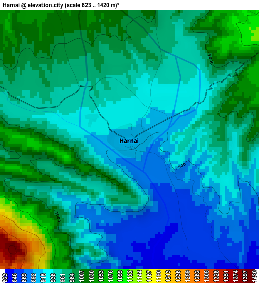
Below is the Elevation map of Harnai, which displays elevation range with different colors. Scale of the first map is from 823 to 1420 m (2700 to 4659 ft) with average elevation of 962.9 meters (=3159 ft) [note 1]
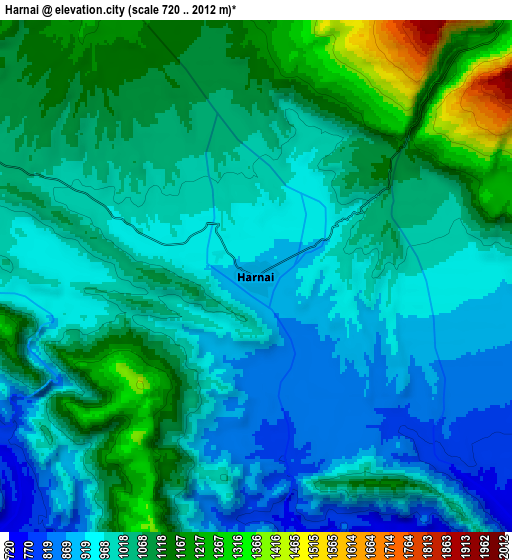
These maps also provides idea of topography and contour of this city, they are displayed at different zoom levels. More info about maps, scale and edge coordinates you can find below images.
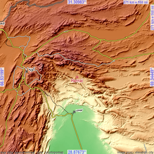
| \ | Map #1 | Map #2 | Topo.Map |
| Scale [m] | 823..1420 m | 720..2012 m | × |
| Scale [ft] | 2700..4659 ft | 2362..6601 ft | × |
| Average | 962.9 m = 3159 ft | 1028.4 m = 3374 ft | × |
| Width | 8.45 km = 5.3 mi | 16.91 km = 10.5 mi | 270.5 km = 168.1 mi |
| Height | 8.45 km = 5.3 mi | 16.91 km = 10.5 mi | 270.5 km = 168.1 mi |
| ↑Max Latitude | 30.138782° | 30.176779° | 31.30983° |
| Latitude at center | 30.10077° | 30.10077° | 30.10077° |
| ↓Min Latitude | 30.062744° | 30.024703° | 28.87673° |
| ← Min Longitude | 67.894295° | 67.850349° | 66.53199° |
| Longitude center | 67.93824° | 67.93824° | 67.93824° |
| →Max Longitude | 67.982185° | 68.026131° | 69.34449° |
Nearby cities:
Cities around Harnai sort by population:
• Quetta elevation 1683 m
90.6 km,  275°
275°
• Kot Malik Barkhurdar 1651 m
92.1 km, 277°
• Sibi 136 m
62.3 km,  185°
185°
• Loralai 1440 m
70.1 km,  64°
64°
• Pishin 1541 m
105.2 km,  300°
300°
• Mach 977 m
64.2 km,  245°
245°
• Dadhar 160 m
74.9 km,  201°
201°
• Alik Ghund 2239 m
58.9 km,  317°
317°
• Khadan Khak 1939 m
75.6 km,  343°
343°
• Duki 1092 m
61.3 km,  84°
84°
• Ziarat 2433 m
37.4 km,  326°
326°
• Qila Saifullah 1561 m
78 km,  31°
31°
Multilingual:
 En español:
Harnai elevación 903 m.
 En France:
Harnai élévation 903 m.


Sources and notes:
- [note 1] Map square and city borders are not equal. Map elevation data is calculated only from area inside that square.
- [src 1] Elevation data from geonames database provided with same terms of usage.
- [src 2] The elevation map of Harnai is generated using elevation data from NASA's 3 arcsec (90m) resolution SRTM data.
- [src 3] Base (background) map © OpenStreetMap contributors tiles are generated by Geofabrik and OpenTopoMap.
Copyright & License:
This Harnai Elevation Map is licensed under CC BY-SA. You may reuse any part from this page, if you give a proper credit by linking to this URL:
 More info on terms of use page.