Parachinar elevation
Parachinar (FATA), Pakistan elevation is 1743 meters and Parachinar elevation in feet is 5719 ft above sea level [src 1]. Parachinar is a seat of a first-order administrative division (feature code) with elevation that is 1397 meters (4583 ft) bigger than average city elevation in Pakistan.
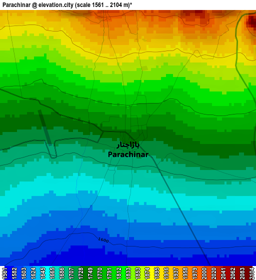
Below is the Elevation map of Parachinar, which displays elevation range with different colors. Scale of the first map is from 1561 to 2104 m (5121 to 6903 ft) with average elevation of 1746.8 meters (=5731 ft) [note 1]
These maps also provides idea of topography and contour of this city, they are displayed at different zoom levels. More info about maps, scale and edge coordinates you can find below images.
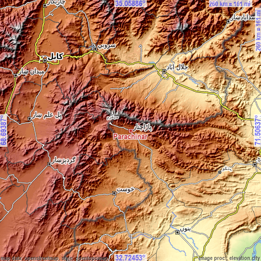
| \ | Map #1 | Topo.Map |
| Scale [m] | 1561..2104 m | × |
| Scale [ft] | 5121..6903 ft | × |
| Average | 1746.8 m = 5731 ft | × |
| Width | 8.11 km = 5 mi | 259.6 km = 161.3 mi |
| Height | 8.11 km = 5 mi | 259.6 km = 161.3 mi |
| ↑Max Latitude | 33.936147° | 35.05886° |
| Latitude at center | 33.89968° | 33.89968° |
| ↓Min Latitude | 33.863197° | 32.72453° |
| ← Min Longitude | 70.056175° | 68.69387° |
| Longitude center | 70.10012° | 70.10012° |
| →Max Longitude | 70.144065° | 71.50637° |
Nearby cities:
Cities around Parachinar sort by population:
• Peshawar elevation 340 m
136.9 km,  84°
84°
• Kohat 503 m
129.6 km,  105°
105°
• Bannu 379 m
111.9 km,  155°
155°
• Hangu 840 m
97.7 km, 114°
• Sarai Naurang 305 m
135.1 km,  152°
152°
• Lachi 463 m
128.1 km,  116°
116°
• Karak 582 m
126.8 km,  133°
133°
• Doaba 890 m
79.1 km, 131°
• Miran Shah 916 m
100 km,  181°
181°
• Alizai 979 m
46.4 km, 150°
• Landi Kotal 1064 m
98.5 km, 77°
• Shinpokh 402 m
110.2 km,  64°
64°
Multilingual:
 En español:
Parachinar elevación 1743 m.
 En France:
Parachinar élévation 1743 m.
 Auf Deutsch:
Parachinar höhe über dem Meeresspiegel ist 1743 m.

Sources and notes:
- [note 1] Map square and city borders are not equal. Map elevation data is calculated only from area inside that square.
- [src 1] Elevation data from geonames database provided with same terms of usage.
- [src 2] The elevation map of Parachinar is generated using elevation data from NASA's 3 arcsec (90m) resolution SRTM data.
- [src 3] Base (background) map © OpenStreetMap contributors tiles are generated by Geofabrik and OpenTopoMap.
Copyright & License:
This Parachinar Elevation Map is licensed under CC BY-SA. You may reuse any part from this page, if you give a proper credit by linking to this URL:
 More info on terms of use page.