Tank elevation
Tank (Khyber Pakhtunkhwa), Pakistan elevation is 259 meters and Tank elevation in feet is 850 ft above sea level [src 1]. Tank is a seat of a second-order administrative division (feature code) with elevation that is 87 meters (285 ft) smaller than average city elevation in Pakistan.
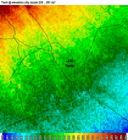
Below is the Elevation map of Tank, which displays elevation range with different colors. Scale of the first map is from 239 to 291 m (784 to 955 ft) with average elevation of 260.1 meters (=853 ft) [note 1]
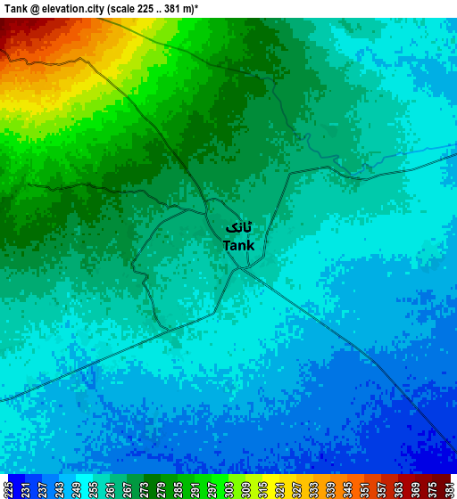
These maps also provides idea of topography and contour of this city, they are displayed at different zoom levels. More info about maps, scale and edge coordinates you can find below images.
| \ | Map #1 | Map #2 | Topo.Map |
| Scale [m] | 239..291 m | 225..381 m | × |
| Scale [ft] | 784..955 ft | 738..1250 ft | × |
| Average | 260.1 m = 853 ft | 262.2 m = 860 ft | × |
| Width | 8.27 km = 5.1 mi | 16.54 km = 10.3 mi | 264.6 km = 164.4 mi |
| Height | 8.27 km = 5.1 mi | 16.54 km = 10.3 mi | 264.6 km = 164.4 mi |
| ↑Max Latitude | 32.254242° | 32.291398° | 33.39897° |
| Latitude at center | 32.21707° | 32.21707° | 32.21707° |
| ↓Min Latitude | 32.179883° | 32.142681° | 31.0196° |
| ← Min Longitude | 70.339205° | 70.295259° | 68.9769° |
| Longitude center | 70.38315° | 70.38315° | 70.38315° |
| →Max Longitude | 70.427095° | 70.471041° | 71.7894° |
Nearby cities:
Cities around Tank sort by population:
• Dera Ismail Khan elevation 177 m
65 km,  131°
131°
• Bhakkar 171 m
91.9 km,  135°
135°
• Shorkot 182 m
57.7 km, 126°
• Bannu 379 m
87.9 km,  13°
13°
• Lakki 267 m
66 km,  48°
48°
• Kalur Kot 191 m
83.4 km,  94°
94°
• Kulachi 218 m
32.7 km,  167°
167°
• Sarai Naurang 305 m
77.3 km,  28°
28°
• Paharpur 182 m
56.7 km,  102°
102°
• Darya Khan 176 m
83.1 km, 125°
• Wana 1390 m
76.8 km,  276°
276°
• Gulishah Kach 1156 m
50.6 km,  355°
355°
Multilingual:
 En español:
Tank elevación 259 m.
 En France:
Tank élévation 259 m.


Sources and notes:
- [note 1] Map square and city borders are not equal. Map elevation data is calculated only from area inside that square.
- [src 1] Elevation data from geonames database provided with same terms of usage.
- [src 2] The elevation map of Tank is generated using elevation data from NASA's 3 arcsec (90m) resolution SRTM data.
- [src 3] Base (background) map © OpenStreetMap contributors tiles are generated by Geofabrik and OpenTopoMap.
Copyright & License:
This Tank Elevation Map is licensed under CC BY-SA. You may reuse any part from this page, if you give a proper credit by linking to this URL:
 More info on terms of use page.