Bontoc elevation
Bontoc (Cordillera, Mountain Province), Philippines elevation is 864 meters and Bontoc elevation in feet is 2835 ft above sea level [src 1]. Bontoc is a seat of a third-order administrative division (feature code) with elevation that is 776 meters (2546 ft) bigger than average city elevation in Philippines.
Below is the Elevation map of Bontoc, which displays elevation range with different colors. Scale of the first map is from 784 to 1831 m (2572 to 6007 ft) with average elevation of 1164.3 meters (=3820 ft) [note 1]
These maps also provides idea of topography and contour of this city, they are displayed at different zoom levels. More info about maps, scale and edge coordinates you can find below images.
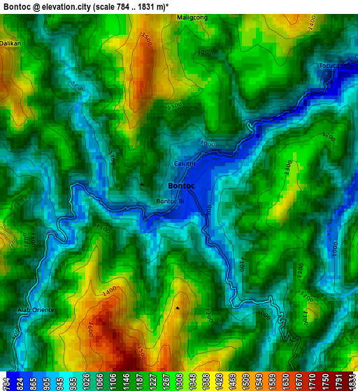
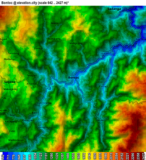
| \ | Map #1 | Map #2 | Topo.Map |
| Scale [m] | 784..1831 m | 642..2427 m | × |
| Scale [ft] | 2572..6007 ft | 2106..7963 ft | × |
| Average | 1164.3 m = 3820 ft | 1370.1 m = 4495 ft | × |
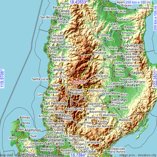
| Width | 9.34 km = 5.8 mi | 18.68 km = 11.6 mi | 298.9 km = 185.7 mi |
| Height | 9.34 km = 5.8 mi | 18.68 km = 11.6 mi | 298.9 km = 185.7 mi |
| ↑Max Latitude | 17.129311° | 17.171302° | 18.42653° |
| Latitude at center | 17.08731° | 17.08731° | 17.08731° |
| ↓Min Latitude | 17.0453° | 17.00328° | 15.7384° |
| ← Min Longitude | 120.932905° | 120.888959° | 119.5706° |
| Longitude center | 120.97685° | 120.97685° | 120.97685° |
| →Max Longitude | 121.020795° | 121.064741° | 122.3831° |
Nearby cities:
Cities around Bontoc sort by population:
• Barlig elevation 1474 m
14.6 km,  112°
112°
• Guinsadan 1279 m
17.9 km,  220°
220°
• Sadsadan 1361 m
20.7 km,  214°
214°
• Sagada 1523 m
8.2 km,  267°
267°
• Tadian 1331 m
19.5 km,  238°
238°
• Banaue 1044 m
21.3 km,  154°
154°
• Bocos 1172 m
19.8 km, 154°
• Besao 1393 m
12.7 km, 273°
• Betwagan 868 m
1.2 km,  247°
247°
• Bauko 1284 m
15.9 km,  227°
227°
• Sabangan 1041 m
10.9 km, 211°
• Sadanga 1249 m
9.7 km,  26°
26°
Multilingual:
 En español:
Bontoc elevación 864 m.
 En France:
Bontoc élévation 864 m.


Sources and notes:
- [note 1] Map square and city borders are not equal. Map elevation data is calculated only from area inside that square.
- [src 1] Elevation data from geonames database provided with same terms of usage.
- [src 2] The elevation map of Bontoc is generated using elevation data from NASA's 3 arcsec (90m) resolution SRTM data.
- [src 3] Base (background) map © OpenStreetMap contributors tiles are generated by Geofabrik and OpenTopoMap.
Copyright & License:
This Bontoc Elevation Map is licensed under CC BY-SA. You may reuse any part from this page, if you give a proper credit by linking to this URL:
 More info on terms of use page.