Barlig elevation
Barlig (Cordillera, Mountain Province), Philippines elevation is 1474 meters and Barlig elevation in feet is 4836 ft above sea level [src 1]. Barlig is a seat of a third-order administrative division (feature code) with elevation that is 1386 meters (4547 ft) bigger than average city elevation in Philippines.
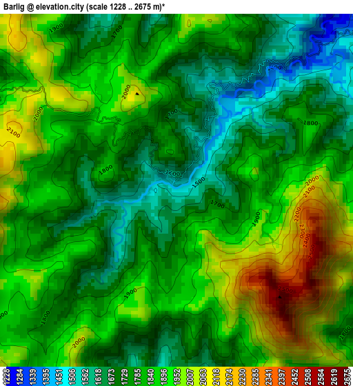
Below is the Elevation map of Barlig, which displays elevation range with different colors. Scale of the first map is from 1228 to 2675 m (4029 to 8776 ft) with average elevation of 1829.9 meters (=6004 ft) [note 1]
These maps also provides idea of topography and contour of this city, they are displayed at different zoom levels. More info about maps, scale and edge coordinates you can find below images.
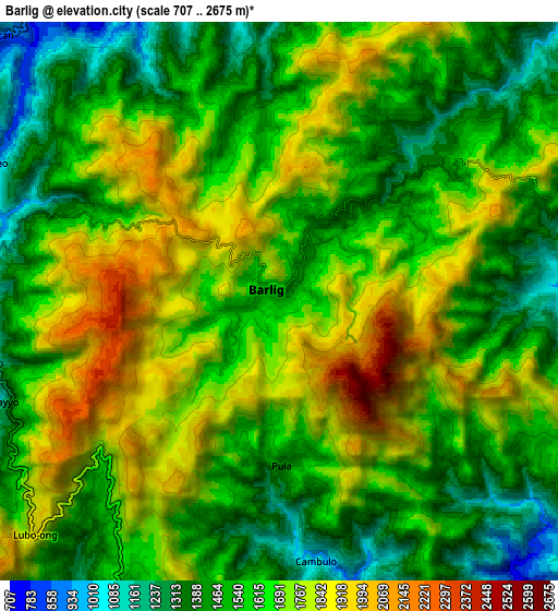
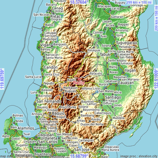
| \ | Map #1 | Map #2 | Topo.Map |
| Scale [m] | 1228..2675 m | 707..2675 m | × |
| Scale [ft] | 4029..8776 ft | 2320..8776 ft | × |
| Average | 1829.9 m = 6004 ft | 1630.5 m = 5349 ft | × |
| Width | 9.34 km = 5.8 mi | 18.69 km = 11.6 mi | 299 km = 185.8 mi |
| Height | 9.34 km = 5.8 mi | 18.69 km = 11.6 mi | 299 km = 185.8 mi |
| ↑Max Latitude | 17.079262° | 17.121265° | 18.37684° |
| Latitude at center | 17.03725° | 17.03725° | 17.03725° |
| ↓Min Latitude | 16.995229° | 16.953198° | 15.68799° |
| ← Min Longitude | 121.059895° | 121.015949° | 119.69759° |
| Longitude center | 121.10384° | 121.10384° | 121.10384° |
| →Max Longitude | 121.147785° | 121.191731° | 122.51009° |
Nearby cities:
Cities around Barlig sort by population:
• Bontoc elevation 864 m
14.6 km,  292°
292°
• Lagawe 490 m
26.4 km,  176°
176°
• Guinsadan 1279 m
26.4 km,  252°
252°
• Sagada 1523 m
22.3 km,  283°
283°
• Banaue 1044 m
14.5 km,  197°
197°
• Bocos 1172 m
13.3 km, 201°
• Hapao 932 m
19.9 km,  208°
208°
• Betwagan 868 m
15.5 km, 289°
• Bauko 1284 m
25.7 km,  258°
258°
• Natonin 973 m
20 km,  66°
66°
• Sabangan 1041 m
19.6 km, 258°
• Sadanga 1249 m
16.9 km,  327°
327°
Multilingual:
 En español:
Barlig elevación 1474 m.
 En France:
Barlig élévation 1474 m.


Sources and notes:
- [note 1] Map square and city borders are not equal. Map elevation data is calculated only from area inside that square.
- [src 1] Elevation data from geonames database provided with same terms of usage.
- [src 2] The elevation map of Barlig is generated using elevation data from NASA's 3 arcsec (90m) resolution SRTM data.
- [src 3] Base (background) map © OpenStreetMap contributors tiles are generated by Geofabrik and OpenTopoMap.
Copyright & License:
This Barlig Elevation Map is licensed under CC BY-SA. You may reuse any part from this page, if you give a proper credit by linking to this URL:
 More info on terms of use page.