Bocos elevation
Bocos (Cordillera, Province of Ifugao), Philippines elevation is 1172 meters and Bocos elevation in feet is 3845 ft above sea level [src 1]. Bocos is a populated place (feature code) with elevation that is 1084 meters (3556 ft) bigger than average city elevation in Philippines.
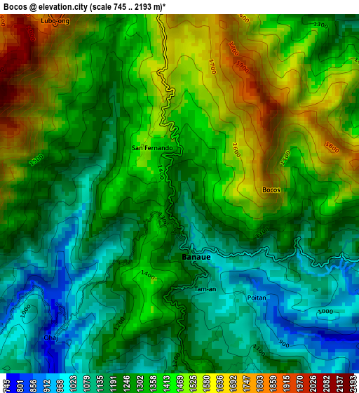
Below is the Elevation map of Bocos, which displays elevation range with different colors. Scale of the first map is from 745 to 2193 m (2444 to 7195 ft) with average elevation of 1325.9 meters (=4350 ft) [note 1]
These maps also provides idea of topography and contour of this city, they are displayed at different zoom levels. More info about maps, scale and edge coordinates you can find below images.
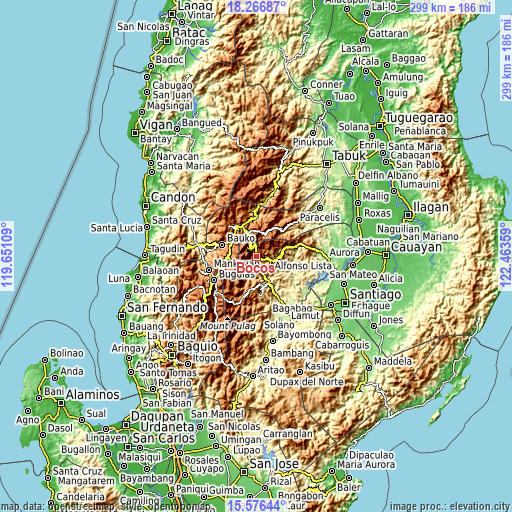
| \ | Map #1 | Topo.Map |
| Scale [m] | 745..2193 m | × |
| Scale [ft] | 2444..7195 ft | × |
| Average | 1325.9 m = 4350 ft | × |
| Width | 9.35 km = 5.8 mi | 299.1 km = 185.9 mi |
| Height | 9.35 km = 5.8 mi | 299.2 km = 185.9 mi |
| ↑Max Latitude | 16.968497° | 18.26687° |
| Latitude at center | 16.92646° | 16.92646° |
| ↓Min Latitude | 16.884414° | 15.57644° |
| ← Min Longitude | 121.013395° | 119.65109° |
| Longitude center | 121.05734° | 121.05734° |
| →Max Longitude | 121.101285° | 122.46359° |
Nearby cities:
Cities around Bocos sort by population:
• Bontoc elevation 864 m
19.8 km,  334°
334°
• Lagawe 490 m
15.5 km,  154°
154°
• Barlig 1474 m
13.3 km,  21°
21°
• Monamon 1957 m
19.1 km,  255°
255°
• Guinsadan 1279 m
20.6 km,  281°
281°
• Sadsadan 1361 m
20.3 km,  272°
272°
• Banaue 1044 m
1.5 km,  161°
161°
• Hapao 932 m
6.8 km,  220°
220°
• Betwagan 868 m
19.9 km, 331°
• Baguinge 596 m
17.3 km, 162°
• Kiangan 796 m
17 km,  169°
169°
• Sabangan 1041 m
16.6 km,  301°
301°
Multilingual:
 En español:
Bocos elevación 1172 m.
 En France:
Bocos élévation 1172 m.


Sources and notes:
- [note 1] Map square and city borders are not equal. Map elevation data is calculated only from area inside that square.
- [src 1] Elevation data from geonames database provided with same terms of usage.
- [src 2] The elevation map of Bocos is generated using elevation data from NASA's 3 arcsec (90m) resolution SRTM data.
- [src 3] Base (background) map © OpenStreetMap contributors tiles are generated by Geofabrik and OpenTopoMap.
Copyright & License:
This Bocos Elevation Map is licensed under CC BY-SA. You may reuse any part from this page, if you give a proper credit by linking to this URL:
 More info on terms of use page.