Tadian elevation
Tadian (Cordillera, Mountain Province), Philippines elevation is 1331 meters and Tadian elevation in feet is 4367 ft above sea level [src 1]. Tadian is a seat of a third-order administrative division (feature code) with elevation that is 1243 meters (4078 ft) bigger than average city elevation in Philippines.
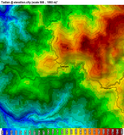
Below is the Elevation map of Tadian, which displays elevation range with different colors. Scale of the first map is from 508 to 1893 m (1667 to 6211 ft) with average elevation of 1136.1 meters (=3727 ft) [note 1]
These maps also provides idea of topography and contour of this city, they are displayed at different zoom levels. More info about maps, scale and edge coordinates you can find below images.
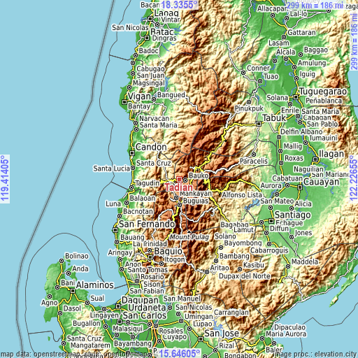
| \ | Map #1 | Topo.Map |
| Scale [m] | 508..1893 m | × |
| Scale [ft] | 1667..6211 ft | × |
| Average | 1136.1 m = 3727 ft | × |
| Width | 9.35 km = 5.8 mi | 299 km = 185.8 mi |
| Height | 9.35 km = 5.8 mi | 299.1 km = 185.9 mi |
| ↑Max Latitude | 17.037621° | 18.3355° |
| Latitude at center | 16.9956° | 16.9956° |
| ↓Min Latitude | 16.953569° | 15.64605° |
| ← Min Longitude | 120.776355° | 119.41405° |
| Longitude center | 120.8203° | 120.8203° |
| →Max Longitude | 120.864245° | 122.22655° |
Nearby cities:
Cities around Tadian sort by population:
• Mankayan elevation 1203 m
15.2 km,  195°
195°
• Monamon 1957 m
14.2 km,  151°
151°
• Guinsadan 1279 m
6.2 km,  124°
124°
• Tabio 1397 m
16.3 km,  187°
187°
• Comillas Norte 515 m
8.8 km,  242°
242°
• Bulalacao 1571 m
17.8 km,  184°
184°
• Cervantes 502 m
9 km,  266°
266°
• Sadsadan 1361 m
8.5 km,  144°
144°
• Sagada 1523 m
12.9 km,  40°
40°
• Besao 1393 m
11.8 km,  19°
19°
• Sabangan 1041 m
11 km,  85°
85°
• Bauko 1284 m
5 km,  97°
97°
Multilingual:
 En español:
Tadian elevación 1331 m.
 En France:
Tadian élévation 1331 m.


Sources and notes:
- [note 1] Map square and city borders are not equal. Map elevation data is calculated only from area inside that square.
- [src 1] Elevation data from geonames database provided with same terms of usage.
- [src 2] The elevation map of Tadian is generated using elevation data from NASA's 3 arcsec (90m) resolution SRTM data.
- [src 3] Base (background) map © OpenStreetMap contributors tiles are generated by Geofabrik and OpenTopoMap.
Copyright & License:
This Tadian Elevation Map is licensed under CC BY-SA. You may reuse any part from this page, if you give a proper credit by linking to this URL:
 More info on terms of use page.