Burgos elevation
Burgos (Central Luzon, Province of Nueva Ecija), Philippines elevation is 402 meters and Burgos elevation in feet is 1319 ft above sea level [src 1]. Burgos is a populated place (feature code) with elevation that is 314 meters (1030 ft) bigger than average city elevation in Philippines.
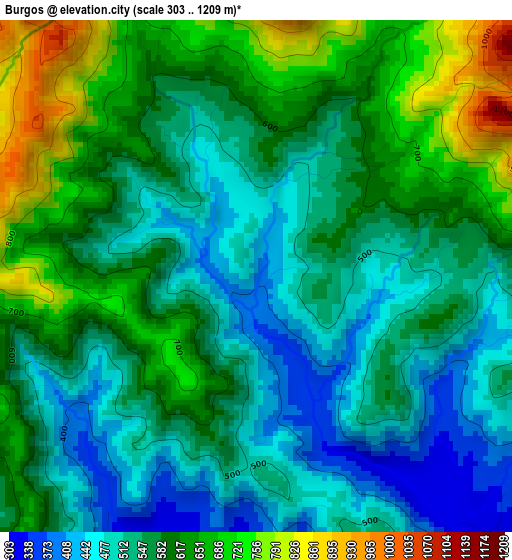
Below is the Elevation map of Burgos, which displays elevation range with different colors. Scale of the first map is from 303 to 1209 m (994 to 3967 ft) with average elevation of 572.3 meters (=1878 ft) [note 1]
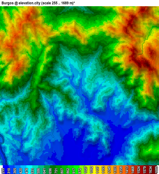
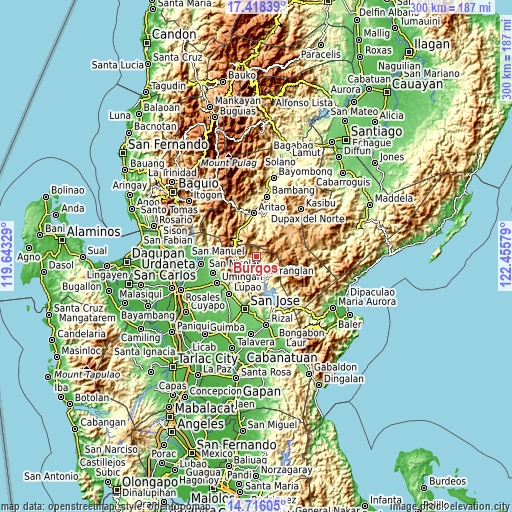
These maps also provides idea of topography and contour of this city, they are displayed at different zoom levels. More info about maps, scale and edge coordinates you can find below images.
| \ | Map #1 | Map #2 | Topo.Map |
| Scale [m] | 303..1209 m | 255..1689 m | × |
| Scale [ft] | 994..3967 ft | 837..5541 ft | × |
| Average | 572.3 m = 1878 ft | 733.1 m = 2405 ft | × |
| Width | 9.39 km = 5.8 mi | 18.78 km = 11.7 mi | 300.5 km = 186.7 mi |
| Height | 9.39 km = 5.8 mi | 18.78 km = 11.7 mi | 300.5 km = 186.7 mi |
| ↑Max Latitude | 16.114033° | 16.156248° | 17.41839° |
| Latitude at center | 16.07181° | 16.07181° | 16.07181° |
| ↓Min Latitude | 16.029578° | 15.987337° | 14.71605° |
| ← Min Longitude | 121.005595° | 120.961649° | 119.64329° |
| Longitude center | 121.04954° | 121.04954° | 121.04954° |
| →Max Longitude | 121.093485° | 121.137431° | 122.45579° |
Nearby cities:
Cities around Burgos sort by population:
• Carranglan elevation 247 m
12.4 km,  172°
172°
• Lupao 146 m
26.8 km,  217°
217°
• Aritao 389 m
25.2 km,  356°
356°
• Bone South 449 m
20.1 km,  343°
343°
• Tayabo 157 m
26.5 km,  184°
184°
• Puncan 294 m
19.4 km,  198°
198°
• Digdig 283 m
15.7 km,  209°
209°
• Malasin 365 m
26.6 km,  13°
13°
• Conversion 269 m
21 km,  156°
156°
• Belance 817 m
24.7 km,  59°
59°
• Nancalobasaan 109 m
26.9 km,  235°
235°
• Santa Fe 567 m
15.4 km,  309°
309°
Multilingual:
 En español:
Burgos elevación 402 m.
 En France:
Burgos élévation 402 m.


Sources and notes:
- [note 1] Map square and city borders are not equal. Map elevation data is calculated only from area inside that square.
- [src 1] Elevation data from geonames database provided with same terms of usage.
- [src 2] The elevation map of Burgos is generated using elevation data from NASA's 3 arcsec (90m) resolution SRTM data.
- [src 3] Base (background) map © OpenStreetMap contributors tiles are generated by Geofabrik and OpenTopoMap.
Copyright & License:
This Burgos Elevation Map is licensed under CC BY-SA. You may reuse any part from this page, if you give a proper credit by linking to this URL:
 More info on terms of use page.