Santa Fe elevation
Santa Fe (Cagayan Valley, Province of Nueva Vizcaya), Philippines elevation is 567 meters and Santa Fe elevation in feet is 1860 ft above sea level [src 1]. Santa Fe is a seat of a third-order administrative division (feature code) with elevation that is 479 meters (1572 ft) bigger than average city elevation in Philippines.
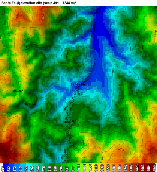
Below is the Elevation map of Santa Fe, which displays elevation range with different colors. Scale of the first map is from 491 to 1544 m (1611 to 5066 ft) with average elevation of 895 meters (=2936 ft) [note 1]
These maps also provides idea of topography and contour of this city, they are displayed at different zoom levels. More info about maps, scale and edge coordinates you can find below images.
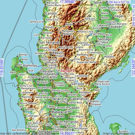
| \ | Map #1 | Topo.Map |
| Scale [m] | 491..1544 m | × |
| Scale [ft] | 1611..5066 ft | × |
| Average | 895 m = 2936 ft | × |
| Width | 9.39 km = 5.8 mi | 300.3 km = 186.6 mi |
| Height | 9.39 km = 5.8 mi | 300.4 km = 186.7 mi |
| ↑Max Latitude | 16.201705° | 17.50546° |
| Latitude at center | 16.1595° | 16.1595° |
| ↓Min Latitude | 16.117286° | 14.80431° |
| ← Min Longitude | 120.894155° | 119.53185° |
| Longitude center | 120.9381° | 120.9381° |
| →Max Longitude | 120.982045° | 122.34435° |
Nearby cities:
Cities around Santa Fe sort by population:
• Aritao elevation 389 m
18.5 km,  33°
33°
• Bone South 449 m
11.3 km, 33°
• Natividad 94 m
19.6 km,  229°
229°
• Burgos 402 m
15.4 km,  129°
129°
• Digdig 283 m
23.8 km,  169°
169°
• Alac 100 m
23.7 km,  216°
216°
• Lagasit 93 m
24 km, 219°
• Banganan 360 m
21.2 km,  35°
35°
• Cabalitian 122 m
17.5 km,  243°
243°
• San Quintin 109 m
23.5 km,  214°
214°
• Kayapa 1109 m
22.9 km,  346°
346°
• San Nicolas 87 m
21.2 km, 242°
Multilingual:
 En español:
Santa Fe elevación 567 m.
 En France:
Santa Fe élévation 567 m.
 Auf Deutsch:
Santa Fe höhe über dem Meeresspiegel ist 567 m.

Sources and notes:
- [note 1] Map square and city borders are not equal. Map elevation data is calculated only from area inside that square.
- [src 1] Elevation data from geonames database provided with same terms of usage.
- [src 2] The elevation map of Santa Fe is generated using elevation data from NASA's 3 arcsec (90m) resolution SRTM data.
- [src 3] Base (background) map © OpenStreetMap contributors tiles are generated by Geofabrik and OpenTopoMap.
Copyright & License:
This Santa Fe Elevation Map is licensed under CC BY-SA. You may reuse any part from this page, if you give a proper credit by linking to this URL:
 More info on terms of use page.