Natividad elevation
Natividad (Ilocos, Province of Pangasinan), Philippines elevation is 94 meters and Natividad elevation in feet is 308 ft above sea level [src 1]. Natividad is a seat of a third-order administrative division (feature code) with elevation that is 6 meters (20 ft) bigger than average city elevation in Philippines.
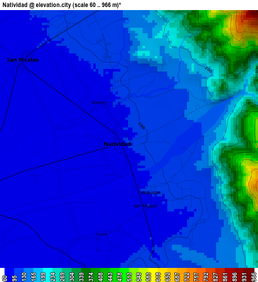
Below is the Elevation map of Natividad, which displays elevation range with different colors. Scale of the first map is from 60 to 966 m (197 to 3169 ft) with average elevation of 144.2 meters (=473 ft) [note 1]
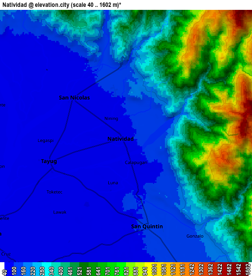
These maps also provides idea of topography and contour of this city, they are displayed at different zoom levels. More info about maps, scale and edge coordinates you can find below images.
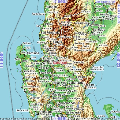
| \ | Map #1 | Map #2 | Topo.Map |
| Scale [m] | 60..966 m | 40..1602 m | × |
| Scale [ft] | 197..3169 ft | 131..5256 ft | × |
| Average | 144.2 m = 473 ft | 295.2 m = 969 ft | × |
| Width | 9.39 km = 5.8 mi | 18.78 km = 11.7 mi | 300.5 km = 186.7 mi |
| Height | 9.39 km = 5.8 mi | 18.78 km = 11.7 mi | 300.5 km = 186.7 mi |
| ↑Max Latitude | 16.086529° | 16.128749° | 17.39108° |
| Latitude at center | 16.0443° | 16.0443° | 16.0443° |
| ↓Min Latitude | 16.002062° | 15.959815° | 14.68836° |
| ← Min Longitude | 120.754755° | 120.710809° | 119.39245° |
| Longitude center | 120.7987° | 120.7987° | 120.7987° |
| →Max Longitude | 120.842645° | 120.886591° | 122.20495° |
Nearby cities:
Cities around Natividad sort by population:
• Guiset East elevation 71 m
12.6 km,  281°
281°
• Tayug 62 m
6.2 km,  252°
252°
• Bantog 50 m
12 km, 250°
• Alac 100 m
6.3 km,  172°
172°
• Lagasit 93 m
5.7 km,  185°
185°
• Panganiban 74 m
4.8 km,  211°
211°
• Cabalaoangan 77 m
7 km, 193°
• Carriedo 67 m
4.9 km, 252°
• Magallanes 62 m
6.9 km, 246°
• Cabalitian 122 m
4.9 km,  351°
351°
• San Quintin 109 m
6.7 km, 166°
• San Nicolas 87 m
4.8 km,  306°
306°
Multilingual:
 En español:
Natividad elevación 94 m.
 En France:
Natividad élévation 94 m.
 Auf Deutsch:
Natividad höhe über dem Meeresspiegel ist 94 m.

Sources and notes:
- [note 1] Map square and city borders are not equal. Map elevation data is calculated only from area inside that square.
- [src 1] Elevation data from geonames database provided with same terms of usage.
- [src 2] The elevation map of Natividad is generated using elevation data from NASA's 3 arcsec (90m) resolution SRTM data.
- [src 3] Base (background) map © OpenStreetMap contributors tiles are generated by Geofabrik and OpenTopoMap.
Copyright & License:
This Natividad Elevation Map is licensed under CC BY-SA. You may reuse any part from this page, if you give a proper credit by linking to this URL:
 More info on terms of use page.