Cabalaoangan elevation
Cabalaoangan (Ilocos, Province of Pangasinan), Philippines elevation is 77 meters and Cabalaoangan elevation in feet is 253 ft above sea level [src 1]. Cabalaoangan is a populated place (feature code) with elevation that is 11 meters (36 ft) smaller than average city elevation in Philippines.
Below is the Elevation map of Cabalaoangan, which displays elevation range with different colors. Scale of the first map is from 46 to 164 m (151 to 538 ft) with average elevation of 77.2 meters (=253 ft) [note 1]
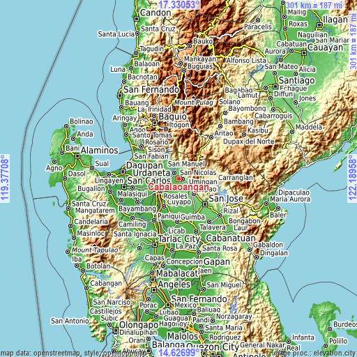
These maps also provides idea of topography and contour of this city, they are displayed at different zoom levels. More info about maps, scale and edge coordinates you can find below images.
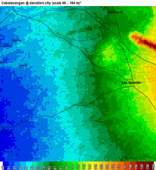
| \ | Map #1 | Topo.Map |
| Scale [m] | 46..164 m | × |
| Scale [ft] | 151..538 ft | × |
| Average | 77.2 m = 253 ft | × |
| Width | 9.39 km = 5.8 mi | 300.6 km = 186.8 mi |
| Height | 9.39 km = 5.8 mi | 300.6 km = 186.8 mi |
| ↑Max Latitude | 16.025572° | 17.33053° |
| Latitude at center | 15.98333° | 15.98333° |
| ↓Min Latitude | 15.941079° | 14.62699° |
| ← Min Longitude | 120.739385° | 119.37708° |
| Longitude center | 120.78333° | 120.78333° |
| →Max Longitude | 120.827275° | 122.18958° |
Nearby cities:
Cities around Cabalaoangan sort by population:
• Tayug elevation 62 m
6.5 km,  318°
318°
• Natividad 94 m
7 km,  13°
13°
• Umingan 96 m
9.4 km,  170°
170°
• Alac 100 m
2.5 km,  78°
78°
• Lagasit 93 m
1.6 km,  45°
45°
• Panganiban 74 m
2.8 km,  342°
342°
• Carriedo 67 m
6.1 km,  330°
330°
• Magallanes 62 m
6.2 km,  310°
310°
• Capandanan 41 m
9.8 km,  254°
254°
• Nancalobasaan 109 m
8.4 km,  130°
130°
• Santa Maria 46 m
8.9 km,  268°
268°
• San Quintin 109 m
3.2 km,  85°
85°
Multilingual:
 En español:
Cabalaoangan elevación 77 m.
 En France:
Cabalaoangan élévation 77 m.
 Auf Deutsch:
Cabalaoangan höhe über dem Meeresspiegel ist 77 m.

Sources and notes:
- [note 1] Map square and city borders are not equal. Map elevation data is calculated only from area inside that square.
- [src 1] Elevation data from geonames database provided with same terms of usage.
- [src 2] The elevation map of Cabalaoangan is generated using elevation data from NASA's 3 arcsec (90m) resolution SRTM data.
- [src 3] Base (background) map © OpenStreetMap contributors tiles are generated by Geofabrik and OpenTopoMap.
Copyright & License:
This Cabalaoangan Elevation Map is licensed under CC BY-SA. You may reuse any part from this page, if you give a proper credit by linking to this URL:
 More info on terms of use page.