Umingan elevation
Umingan (Ilocos, Province of Pangasinan), Philippines elevation is 96 meters and Umingan elevation in feet is 315 ft above sea level [src 1]. Umingan is a seat of a third-order administrative division (feature code) with elevation that is 8 meters (26 ft) bigger than average city elevation in Philippines.
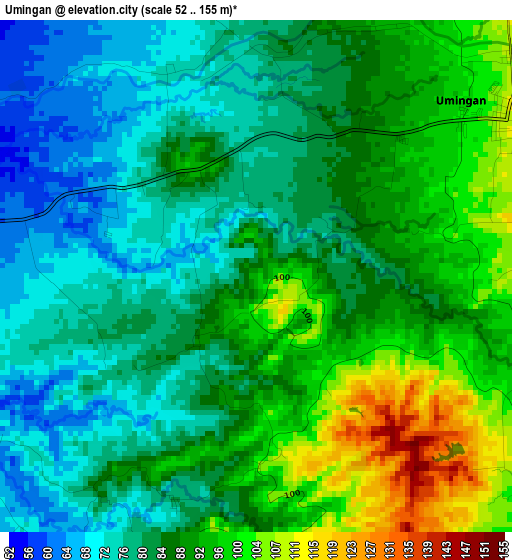
Below is the Elevation map of Umingan, which displays elevation range with different colors. Scale of the first map is from 52 to 155 m (171 to 509 ft) with average elevation of 85.6 meters (=281 ft) [note 1]
These maps also provides idea of topography and contour of this city, they are displayed at different zoom levels. More info about maps, scale and edge coordinates you can find below images.
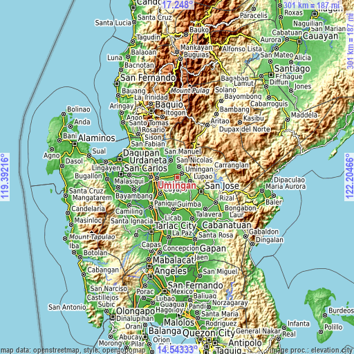
| \ | Map #1 | Map #2 | Topo.Map |
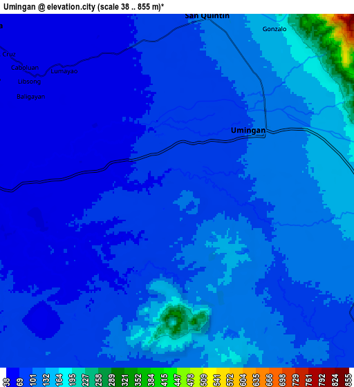
| Scale [m] | 52..155 m | 38..855 m | × |
| Scale [ft] | 171..509 ft | 125..2805 ft | × |
| Average | 85.6 m = 281 ft | 100.7 m = 330 ft | × |
| Width | 9.4 km = 5.8 mi | 18.8 km = 11.7 mi | 300.7 km = 186.8 mi |
| Height | 9.4 km = 5.8 mi | 18.8 km = 11.7 mi | 300.8 km = 186.9 mi |
| ↑Max Latitude | 15.94247° | 15.98472° | 17.248° |
| Latitude at center | 15.90021° | 15.90021° | 15.90021° |
| ↓Min Latitude | 15.857942° | 15.815664° | 14.54333° |
| ← Min Longitude | 120.754465° | 120.710519° | 119.39216° |
| Longitude center | 120.79841° | 120.79841° | 120.79841° |
| →Max Longitude | 120.842355° | 120.886301° | 122.20466° |
Nearby cities:
Cities around Umingan sort by population:
• Lupao elevation 146 m
10.9 km,  102°
102°
• Diaz 105 m
7.1 km,  147°
147°
• Alac 100 m
9.8 km,  5°
5°
• Lagasit 93 m
10.4 km,  357°
357°
• Esmeralda 55 m
9.6 km,  247°
247°
• Cabalaoangan 77 m
9.4 km,  350°
350°
• Paitan Norte 79 m
9.7 km,  219°
219°
• Baloy 85 m
10.9 km,  193°
193°
• Sampaloc 102 m
11.8 km,  141°
141°
• Nancalobasaan 109 m
6.1 km,  51°
51°
• Balungao 43 m
11.8 km,  268°
268°
• San Quintin 109 m
9.6 km, 9°
Multilingual:
 En español:
Umingan elevación 96 m.
 En France:
Umingan élévation 96 m.


Sources and notes:
- [note 1] Map square and city borders are not equal. Map elevation data is calculated only from area inside that square.
- [src 1] Elevation data from geonames database provided with same terms of usage.
- [src 2] The elevation map of Umingan is generated using elevation data from NASA's 3 arcsec (90m) resolution SRTM data.
- [src 3] Base (background) map © OpenStreetMap contributors tiles are generated by Geofabrik and OpenTopoMap.
Copyright & License:
This Umingan Elevation Map is licensed under CC BY-SA. You may reuse any part from this page, if you give a proper credit by linking to this URL:
 More info on terms of use page.