Kayapa elevation
Kayapa (Cagayan Valley, Province of Nueva Vizcaya), Philippines elevation is 1109 meters and Kayapa elevation in feet is 3638 ft above sea level [src 1]. Kayapa is a seat of a third-order administrative division (feature code) with elevation that is 1021 meters (3350 ft) bigger than average city elevation in Philippines.
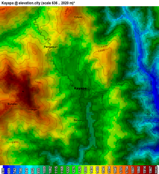
Below is the Elevation map of Kayapa, which displays elevation range with different colors. Scale of the first map is from 636 to 2020 m (2087 to 6627 ft) with average elevation of 1273.7 meters (=4179 ft) [note 1]
These maps also provides idea of topography and contour of this city, they are displayed at different zoom levels. More info about maps, scale and edge coordinates you can find below images.
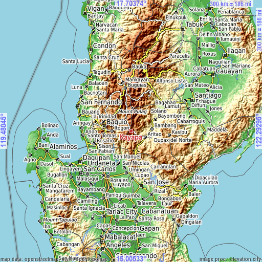
| \ | Map #1 | Topo.Map |
| Scale [m] | 636..2020 m | × |
| Scale [ft] | 2087..6627 ft | × |
| Average | 1273.7 m = 4179 ft | × |
| Width | 9.38 km = 5.8 mi | 300 km = 186.4 mi |
| Height | 9.38 km = 5.8 mi | 300.1 km = 186.5 mi |
| ↑Max Latitude | 16.401362° | 17.70374° |
| Latitude at center | 16.3592° | 16.3592° |
| ↓Min Latitude | 16.317029° | 15.00533° |
| ← Min Longitude | 120.842755° | 119.48045° |
| Longitude center | 120.8867° | 120.8867° |
| →Max Longitude | 120.930645° | 122.29295° |
Nearby cities:
Cities around Kayapa sort by population:
• Itogon elevation 808 m
22.4 km,  271°
271°
• Bambang 329 m
23.7 km,  82°
82°
• Aritao 389 m
17.2 km,  113°
113°
• Bone South 449 m
17.3 km,  137°
137°
• Ineangan 355 m
22.5 km,  101°
101°
• Almaguer North 343 m
22 km,  92°
92°
• Ambuclao 761 m
20.1 km,  313°
313°
• Banganan 360 m
18.6 km, 105°
• Dalupirip 407 m
17.7 km,  257°
257°
• Salinas 416 m
14.1 km, 85°
• Santa Fe 567 m
22.9 km,  166°
166°
• Bokod 906 m
15.6 km,  337°
337°
Multilingual:
 En español:
Kayapa elevación 1109 m.
 En France:
Kayapa élévation 1109 m.


Sources and notes:
- [note 1] Map square and city borders are not equal. Map elevation data is calculated only from area inside that square.
- [src 1] Elevation data from geonames database provided with same terms of usage.
- [src 2] The elevation map of Kayapa is generated using elevation data from NASA's 3 arcsec (90m) resolution SRTM data.
- [src 3] Base (background) map © OpenStreetMap contributors tiles are generated by Geofabrik and OpenTopoMap.
Copyright & License:
This Kayapa Elevation Map is licensed under CC BY-SA. You may reuse any part from this page, if you give a proper credit by linking to this URL:
 More info on terms of use page.