Bokod elevation
Bokod (Cordillera, Province of Benguet), Philippines elevation is 906 meters and Bokod elevation in feet is 2972 ft above sea level [src 1]. Bokod is a seat of a third-order administrative division (feature code) with elevation that is 818 meters (2684 ft) bigger than average city elevation in Philippines.
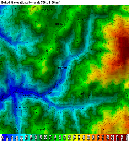
Below is the Elevation map of Bokod, which displays elevation range with different colors. Scale of the first map is from 766 to 2186 m (2513 to 7172 ft) with average elevation of 1270.1 meters (=4167 ft) [note 1]
These maps also provides idea of topography and contour of this city, they are displayed at different zoom levels. More info about maps, scale and edge coordinates you can find below images.
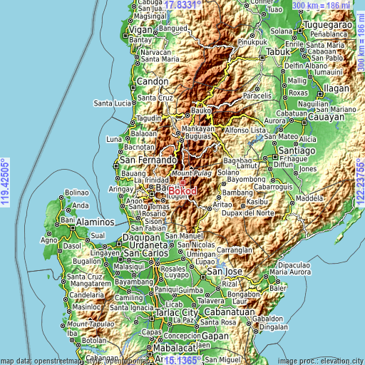
| \ | Map #1 | Topo.Map |
| Scale [m] | 766..2186 m | × |
| Scale [ft] | 2513..7172 ft | × |
| Average | 1270.1 m = 4167 ft | × |
| Width | 9.37 km = 5.8 mi | 299.8 km = 186.3 mi |
| Height | 9.37 km = 5.8 mi | 299.9 km = 186.3 mi |
| ↑Max Latitude | 16.531633° | 17.8331° |
| Latitude at center | 16.4895° | 16.4895° |
| ↓Min Latitude | 16.447357° | 15.1365° |
| ← Min Longitude | 120.787355° | 119.42505° |
| Longitude center | 120.8313° | 120.8313° |
| →Max Longitude | 120.875245° | 122.23755° |
Nearby cities:
Cities around Bokod sort by population:
• Itogon elevation 808 m
21.6 km,  229°
229°
• Tuding 1286 m
22 km,  246°
246°
• Loacan 1045 m
18.8 km,  290°
290°
• Ambuclao 761 m
8.7 km,  265°
265°
• Dalupirip 407 m
21.5 km,  212°
212°
• Salinas 416 m
24 km,  123°
123°
• Amlimay 1642 m
22.7 km,  1°
1°
• Topdac 1573 m
14.7 km,  299°
299°
• Natubleng 2262 m
23.6 km,  346°
346°
• Atok 994 m
17.5 km,  306°
306°
• Kayapa 1109 m
15.6 km,  157°
157°
• Kabayan 1214 m
15 km, 3°
Multilingual:
 En español:
Bokod elevación 906 m.
 En France:
Bokod élévation 906 m.


Sources and notes:
- [note 1] Map square and city borders are not equal. Map elevation data is calculated only from area inside that square.
- [src 1] Elevation data from geonames database provided with same terms of usage.
- [src 2] The elevation map of Bokod is generated using elevation data from NASA's 3 arcsec (90m) resolution SRTM data.
- [src 3] Base (background) map © OpenStreetMap contributors tiles are generated by Geofabrik and OpenTopoMap.
Copyright & License:
This Bokod Elevation Map is licensed under CC BY-SA. You may reuse any part from this page, if you give a proper credit by linking to this URL:
 More info on terms of use page.