Masaya Sur elevation
Masaya Sur (Cagayan Valley, Province of Isabela), Philippines elevation is 111 meters and Masaya Sur elevation in feet is 364 ft above sea level [src 1]. Masaya Sur is a populated place (feature code) with elevation that is 23 meters (75 ft) bigger than average city elevation in Philippines.
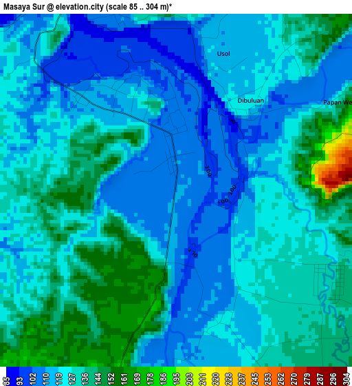
Below is the Elevation map of Masaya Sur, which displays elevation range with different colors. Scale of the first map is from 85 to 304 m (279 to 997 ft) with average elevation of 125.5 meters (=412 ft) [note 1]
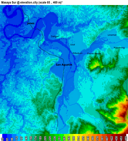
These maps also provides idea of topography and contour of this city, they are displayed at different zoom levels. More info about maps, scale and edge coordinates you can find below images.
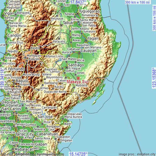
| \ | Map #1 | Map #2 | Topo.Map |
| Scale [m] | 85..304 m | 65..469 m | × |
| Scale [ft] | 279..997 ft | 213..1539 ft | × |
| Average | 125.5 m = 412 ft | 136.2 m = 447 ft | × |
| Width | 9.37 km = 5.8 mi | 18.74 km = 11.6 mi | 299.8 km = 186.3 mi |
| Height | 9.37 km = 5.8 mi | 18.74 km = 11.6 mi | 299.8 km = 186.3 mi |
| ↑Max Latitude | 16.542301° | 16.584423° | 17.8437° |
| Latitude at center | 16.50017° | 16.50017° | 16.50017° |
| ↓Min Latitude | 16.45803° | 16.41588° | 15.14725° |
| ← Min Longitude | 121.703485° | 121.659539° | 120.34118° |
| Longitude center | 121.74743° | 121.74743° | 121.74743° |
| →Max Longitude | 121.791375° | 121.835321° | 123.15368° |
Nearby cities:
Cities around Masaya Sur sort by population:
• Maddela elevation 157 m
18.9 km,  200°
200°
• Echague 76 m
24 km,  341°
341°
• Saguday 104 m
20.1 km,  283°
283°
• Cabarroguis 126 m
24.2 km,  272°
272°
• Soyung 77 m
23.9 km, 338°
• Jones 102 m
7.9 km,  323°
323°
• San Guillermo 102 m
25.9 km,  14°
14°
• Pangal Sur 93 m
13.9 km, 323°
• Dumabato 283 m
21 km,  193°
193°
• Minuri 131 m
12 km,  72°
72°
• Dibuluan 117 m
2.8 km,  41°
41°
• Aglipay 114 m
11 km,  263°
263°
Multilingual:
 En español:
Masaya Sur elevación 111 m.
 En France:
Masaya Sur élévation 111 m.
 Auf Deutsch:
Masaya Sur höhe über dem Meeresspiegel ist 111 m.

Sources and notes:
- [note 1] Map square and city borders are not equal. Map elevation data is calculated only from area inside that square.
- [src 1] Elevation data from geonames database provided with same terms of usage.
- [src 2] The elevation map of Masaya Sur is generated using elevation data from NASA's 3 arcsec (90m) resolution SRTM data.
- [src 3] Base (background) map © OpenStreetMap contributors tiles are generated by Geofabrik and OpenTopoMap.
Copyright & License:
This Masaya Sur Elevation Map is licensed under CC BY-SA. You may reuse any part from this page, if you give a proper credit by linking to this URL:
 More info on terms of use page.