Maddela elevation
Maddela (Cagayan Valley, Province of Quirino), Philippines elevation is 157 meters and Maddela elevation in feet is 515 ft above sea level [src 1]. Maddela is a populated place (feature code) with elevation that is 69 meters (226 ft) bigger than average city elevation in Philippines.
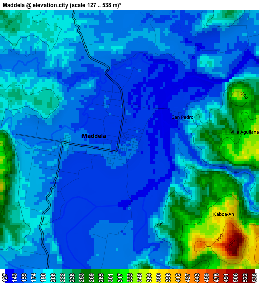
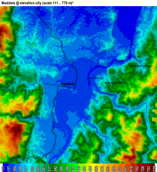
Below is the Elevation map of Maddela, which displays elevation range with different colors. Scale of the first map is from 127 to 538 m (417 to 1765 ft) with average elevation of 195.2 meters (=640 ft) [note 1]
These maps also provides idea of topography and contour of this city, they are displayed at different zoom levels. More info about maps, scale and edge coordinates you can find below images.
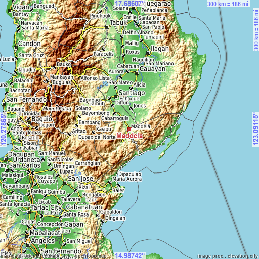
| \ | Map #1 | Map #2 | Topo.Map |
| Scale [m] | 127..538 m | 111..779 m | × |
| Scale [ft] | 417..1765 ft | 364..2556 ft | × |
| Average | 195.2 m = 640 ft | 273.4 m = 897 ft | × |
| Width | 9.38 km = 5.8 mi | 18.76 km = 11.7 mi | 300.1 km = 186.5 mi |
| Height | 9.38 km = 5.8 mi | 18.76 km = 11.7 mi | 300.1 km = 186.5 mi |
| ↑Max Latitude | 16.383565° | 16.425722° | 17.68607° |
| Latitude at center | 16.3414° | 16.3414° | 16.3414° |
| ↓Min Latitude | 16.299225° | 16.257042° | 14.98742° |
| ← Min Longitude | 121.640955° | 121.597009° | 120.27865° |
| Longitude center | 121.6849° | 121.6849° | 121.6849° |
| →Max Longitude | 121.728845° | 121.772791° | 123.09115° |
Nearby cities:
Cities around Maddela sort by population:
• Saguday elevation 104 m
25.9 km,  330°
330°
• Cabarroguis 126 m
25.7 km,  317°
317°
• Nagtipunan 204 m
16.6 km,  213°
213°
• Masaya Sur 111 m
18.9 km,  20°
20°
• Jones 102 m
24.1 km,  4°
4°
• Pangal Sur 93 m
28.8 km,  356°
356°
• Dumabato 283 m
3.2 km,  149°
149°
• Minuri 131 m
27.9 km,  40°
40°
• Dibuluan 117 m
21.5 km, 23°
• Dinalongan 15 m
36.7 km,  127°
127°
• Diffun 134 m
33.6 km, 325°
• Aglipay 114 m
16.9 km,  345°
345°
Multilingual:
 En español:
Maddela elevación 157 m.
 En France:
Maddela élévation 157 m.


Sources and notes:
- [note 1] Map square and city borders are not equal. Map elevation data is calculated only from area inside that square.
- [src 1] Elevation data from geonames database provided with same terms of usage.
- [src 2] The elevation map of Maddela is generated using elevation data from NASA's 3 arcsec (90m) resolution SRTM data.
- [src 3] Base (background) map © OpenStreetMap contributors tiles are generated by Geofabrik and OpenTopoMap.
Copyright & License:
This Maddela Elevation Map is licensed under CC BY-SA. You may reuse any part from this page, if you give a proper credit by linking to this URL:
 More info on terms of use page.