Echague elevation
Echague (Cagayan Valley, Province of Isabela), Philippines elevation is 76 meters and Echague elevation in feet is 249 ft above sea level [src 1]. Echague is a populated place (feature code) with elevation that is 12 meters (39 ft) smaller than average city elevation in Philippines.
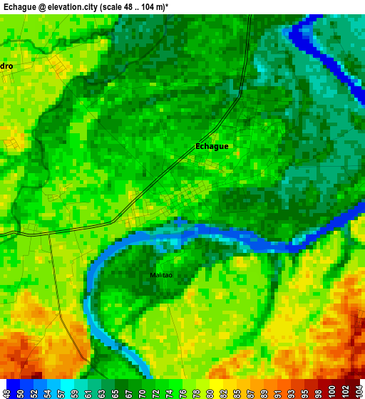
Below is the Elevation map of Echague, which displays elevation range with different colors. Scale of the first map is from 48 to 104 m (157 to 341 ft) with average elevation of 72.6 meters (=238 ft) [note 1]
These maps also provides idea of topography and contour of this city, they are displayed at different zoom levels. More info about maps, scale and edge coordinates you can find below images.
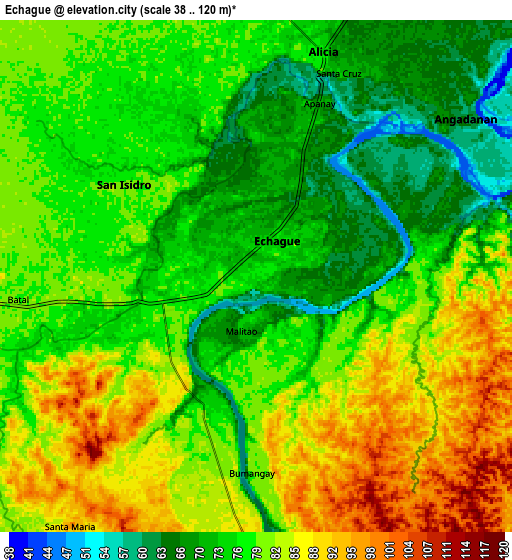
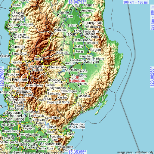
| \ | Map #1 | Map #2 | Topo.Map |
| Scale [m] | 48..104 m | 38..120 m | × |
| Scale [ft] | 157..341 ft | 125..394 ft | × |
| Average | 72.6 m = 238 ft | 78.6 m = 258 ft | × |
| Width | 9.36 km = 5.8 mi | 18.72 km = 11.6 mi | 299.5 km = 186.1 mi |
| Height | 9.36 km = 5.8 mi | 18.72 km = 11.6 mi | 299.5 km = 186.1 mi |
| ↑Max Latitude | 16.747176° | 16.789253° | 18.04713° |
| Latitude at center | 16.70509° | 16.70509° | 16.70509° |
| ↓Min Latitude | 16.662995° | 16.62089° | 15.35355° |
| ← Min Longitude | 121.632385° | 121.588439° | 120.27008° |
| Longitude center | 121.67633° | 121.67633° | 121.67633° |
| →Max Longitude | 121.720275° | 121.764221° | 123.08258° |
Nearby cities:
Cities around Echague sort by population:
• Santiago elevation 86 m
13.7 km,  262°
262°
• Alicia 75 m
8.6 km,  15°
15°
• Batal 76 m
8.3 km, 256°
• Soyung 77 m
1.3 km,  244°
244°
• Angadanan 63 m
9.5 km,  53°
53°
• San Guillermo 102 m
14.4 km,  80°
80°
• Ramos West 80 m
6.7 km, 263°
• Rizal 92 m
13 km,  276°
276°
• Pangal Sur 93 m
11.7 km,  183°
183°
• Malasin 54 m
15.9 km, 46°
• Burgos 73 m
14.6 km, 24°
• San Isidro 78 m
7.1 km,  296°
296°
Multilingual:
 En español:
Echagüe elevación 76 m.
 En France:
Echague élévation 76 m.


Sources and notes:
- [note 1] Map square and city borders are not equal. Map elevation data is calculated only from area inside that square.
- [src 1] Elevation data from geonames database provided with same terms of usage.
- [src 2] The elevation map of Echague is generated using elevation data from NASA's 3 arcsec (90m) resolution SRTM data.
- [src 3] Base (background) map © OpenStreetMap contributors tiles are generated by Geofabrik and OpenTopoMap.
Copyright & License:
This Echague Elevation Map is licensed under CC BY-SA. You may reuse any part from this page, if you give a proper credit by linking to this URL:
 More info on terms of use page.