Angadanan elevation
Angadanan (Cagayan Valley, Province of Isabela), Philippines elevation is 63 meters and Angadanan elevation in feet is 207 ft above sea level [src 1]. Angadanan is a seat of a third-order administrative division (feature code) with elevation that is 25 meters (82 ft) smaller than average city elevation in Philippines.
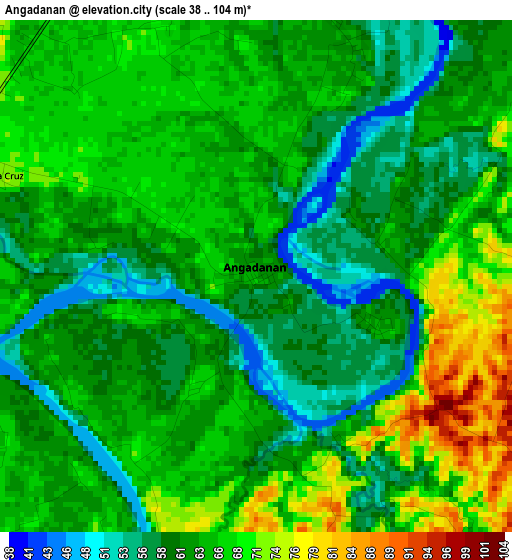
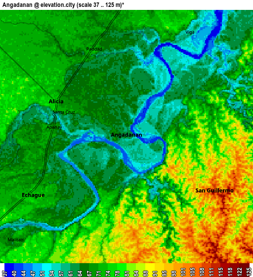
Below is the Elevation map of Angadanan, which displays elevation range with different colors. Scale of the first map is from 38 to 104 m (125 to 341 ft) with average elevation of 63.7 meters (=209 ft) [note 1]
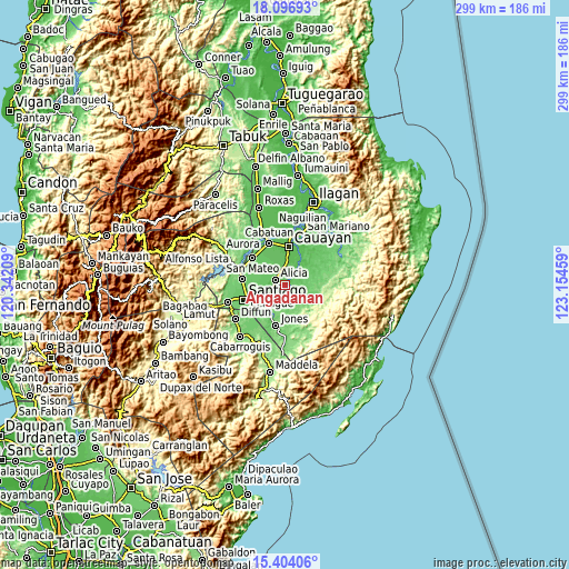
These maps also provides idea of topography and contour of this city, they are displayed at different zoom levels. More info about maps, scale and edge coordinates you can find below images.
| \ | Map #1 | Map #2 | Topo.Map |
| Scale [m] | 38..104 m | 37..125 m | × |
| Scale [ft] | 125..341 ft | 121..410 ft | × |
| Average | 63.7 m = 209 ft | 72.4 m = 238 ft | × |
| Width | 9.36 km = 5.8 mi | 18.72 km = 11.6 mi | 299.4 km = 186 mi |
| Height | 9.36 km = 5.8 mi | 18.72 km = 11.6 mi | 299.4 km = 186 mi |
| ↑Max Latitude | 16.797335° | 16.839401° | 18.09693° |
| Latitude at center | 16.75526° | 16.75526° | 16.75526° |
| ↓Min Latitude | 16.713176° | 16.671082° | 15.40406° |
| ← Min Longitude | 121.704395° | 121.660449° | 120.34209° |
| Longitude center | 121.74834° | 121.74834° | 121.74834° |
| →Max Longitude | 121.792285° | 121.836231° | 123.15459° |
Nearby cities:
Cities around Angadanan sort by population:
• Alicia elevation 75 m
6.1 km,  296°
296°
• Echague 76 m
9.5 km,  233°
233°
• Minante Segundo 63 m
16.4 km,  5°
5°
• Soyung 77 m
10.7 km,  235°
235°
• San Guillermo 102 m
7.3 km,  116°
116°
• Pinoma 69 m
13.9 km,  341°
341°
• Sillawit 62 m
13.2 km, 5°
• Ramos West 80 m
15.7 km,  246°
246°
• Gappal 59 m
11.9 km,  40°
40°
• Malasin 54 m
6.7 km,  34°
34°
• Burgos 73 m
7.9 km,  348°
348°
• San Isidro 78 m
14.2 km,  260°
260°
Multilingual:
 En español:
Angadanan elevación 63 m.
 En France:
Angadanan élévation 63 m.
 Auf Deutsch:
Angadanan höhe über dem Meeresspiegel ist 63 m.

Sources and notes:
- [note 1] Map square and city borders are not equal. Map elevation data is calculated only from area inside that square.
- [src 1] Elevation data from geonames database provided with same terms of usage.
- [src 2] The elevation map of Angadanan is generated using elevation data from NASA's 3 arcsec (90m) resolution SRTM data.
- [src 3] Base (background) map © OpenStreetMap contributors tiles are generated by Geofabrik and OpenTopoMap.
Copyright & License:
This Angadanan Elevation Map is licensed under CC BY-SA. You may reuse any part from this page, if you give a proper credit by linking to this URL:
 More info on terms of use page.