Malinao elevation
Malinao (Soccsksargen, Province of Cotabato), Philippines elevation is 516 meters and Malinao elevation in feet is 1693 ft above sea level [src 1]. Malinao is a populated place (feature code) with elevation that is 428 meters (1404 ft) bigger than average city elevation in Philippines.
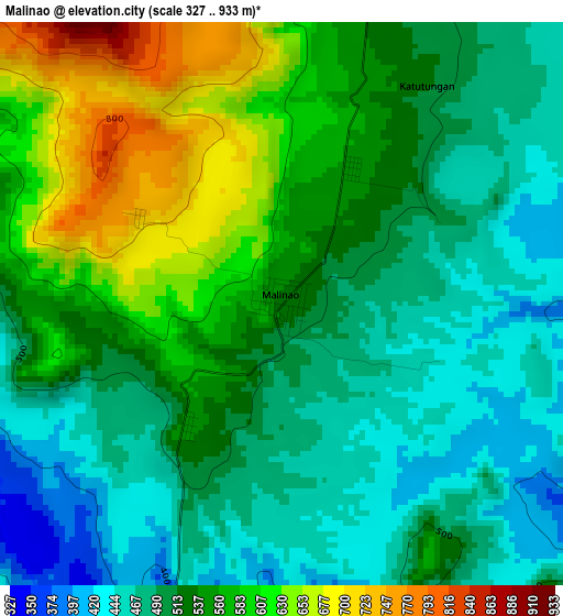
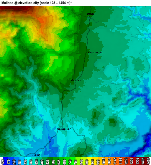
Below is the Elevation map of Malinao, which displays elevation range with different colors. Scale of the first map is from 327 to 933 m (1073 to 3061 ft) with average elevation of 529.7 meters (=1738 ft) [note 1]
These maps also provides idea of topography and contour of this city, they are displayed at different zoom levels. More info about maps, scale and edge coordinates you can find below images.
| \ | Map #1 | Map #2 | Topo.Map |
| Scale [m] | 327..933 m | 128..1454 m | × |
| Scale [ft] | 1073..3061 ft | 420..4770 ft | × |
| Average | 529.7 m = 1738 ft | 523.9 m = 1719 ft | × |
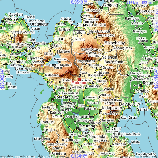
| Width | 9.69 km = 6 mi | 19.38 km = 12 mi | 310 km = 192.6 mi |
| Height | 9.69 km = 6 mi | 19.38 km = 12 mi | 310 km = 192.6 mi |
| ↑Max Latitude | 7.603851° | 7.647408° | 8.95193° |
| Latitude at center | 7.56029° | 7.56029° | 7.56029° |
| ↓Min Latitude | 7.516725° | 7.473155° | 6.16415° |
| ← Min Longitude | 124.664445° | 124.620499° | 123.30214° |
| Longitude center | 124.70839° | 124.70839° | 124.70839° |
| →Max Longitude | 124.752335° | 124.796281° | 126.11464° |
Nearby cities:
Cities around Malinao sort by population:
• Wao elevation 1246 m
14.4 km,  341°
341°
• Kalilangan 874 m
21 km,  11°
11°
• Damulog 281 m
27.2 km,  108°
108°
• Kadingilan 338 m
22.5 km,  78°
78°
• Bau 162 m
18.4 km,  200°
200°
• Banisilan 391 m
7.9 km,  167°
167°
• Kimanuit 521 m
22.3 km,  4°
4°
• Osias 304 m
12.7 km,  69°
69°
• Liliongan 167 m
23.9 km,  157°
157°
• Bangahan 775 m
26.4 km, 6°
• Sampagar 398 m
27.7 km,  100°
100°
• Bumbaran 1191 m
27.4 km,  346°
346°
Multilingual:
 En español:
Malinao elevación 516 m.
 En France:
Malinao élévation 516 m.


Sources and notes:
- [note 1] Map square and city borders are not equal. Map elevation data is calculated only from area inside that square.
- [src 1] Elevation data from geonames database provided with same terms of usage.
- [src 2] The elevation map of Malinao is generated using elevation data from NASA's 3 arcsec (90m) resolution SRTM data.
- [src 3] Base (background) map © OpenStreetMap contributors tiles are generated by Geofabrik and OpenTopoMap.
Copyright & License:
This Malinao Elevation Map is licensed under CC BY-SA. You may reuse any part from this page, if you give a proper credit by linking to this URL:
 More info on terms of use page.