Liliongan elevation
Liliongan (Soccsksargen, Province of Cotabato), Philippines elevation is 167 meters and Liliongan elevation in feet is 548 ft above sea level [src 1]. Liliongan is a populated place (feature code) with elevation that is 79 meters (259 ft) bigger than average city elevation in Philippines.
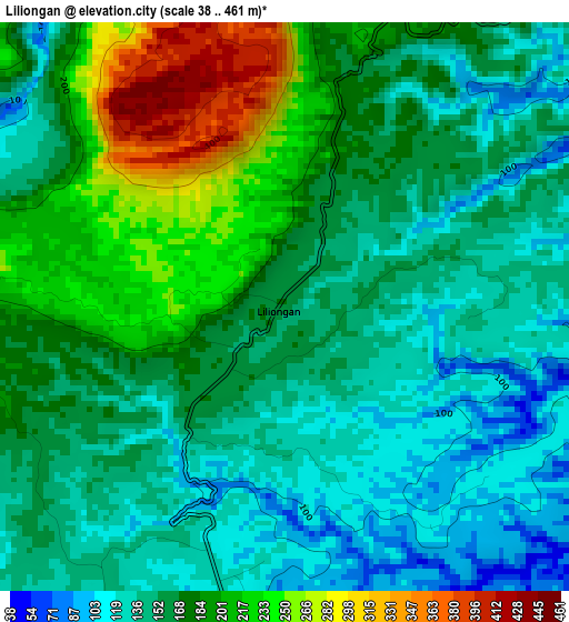
Below is the Elevation map of Liliongan, which displays elevation range with different colors. Scale of the first map is from 38 to 461 m (125 to 1512 ft) with average elevation of 168.7 meters (=553 ft) [note 1]
These maps also provides idea of topography and contour of this city, they are displayed at different zoom levels. More info about maps, scale and edge coordinates you can find below images.
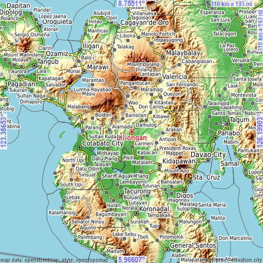
| \ | Map #1 | Topo.Map |
| Scale [m] | 38..461 m | × |
| Scale [ft] | 125..1512 ft | × |
| Average | 168.7 m = 553 ft | × |
| Width | 9.69 km = 6 mi | 310.1 km = 192.7 mi |
| Height | 9.69 km = 6 mi | 310.1 km = 192.7 mi |
| ↑Max Latitude | 7.406361° | 8.75511° |
| Latitude at center | 7.36278° | 7.36278° |
| ↓Min Latitude | 7.319195° | 5.96607° |
| ← Min Longitude | 124.748835° | 123.38653° |
| Longitude center | 124.79278° | 124.79278° |
| →Max Longitude | 124.836725° | 126.19903° |
Nearby cities:
Cities around Liliongan sort by population:
• Damulog elevation 281 m
21.3 km,  50°
50°
• Carmen 43 m
17.6 km,  180°
180°
• Bau 162 m
16.5 km,  286°
286°
• Banisilan 391 m
16.1 km,  332°
332°
• Alamada 80 m
25.1 km,  262°
262°
• Malinao 516 m
23.9 km,  337°
337°
• Malapag 25 m
25.6 km,  174°
174°
• Banawa 34 m
24.6 km,  160°
160°
• Limbalod 19 m
25.6 km, 178°
• Pedtad 26 m
22.6 km, 173°
• Malitubog 81 m
17.9 km,  252°
252°
• Sampagar 398 m
24.6 km, 46°
Multilingual:
 En español:
Liliongan elevación 167 m.
 En France:
Liliongan élévation 167 m.
 Auf Deutsch:
Liliongan höhe über dem Meeresspiegel ist 167 m.

Sources and notes:
- [note 1] Map square and city borders are not equal. Map elevation data is calculated only from area inside that square.
- [src 1] Elevation data from geonames database provided with same terms of usage.
- [src 2] The elevation map of Liliongan is generated using elevation data from NASA's 3 arcsec (90m) resolution SRTM data.
- [src 3] Base (background) map © OpenStreetMap contributors tiles are generated by Geofabrik and OpenTopoMap.
Copyright & License:
This Liliongan Elevation Map is licensed under CC BY-SA. You may reuse any part from this page, if you give a proper credit by linking to this URL:
 More info on terms of use page.