Kimanuit elevation
Kimanuit (Northern Mindanao, Province of Bukidnon), Philippines elevation is 521 meters and Kimanuit elevation in feet is 1709 ft above sea level [src 1]. Kimanuit is a populated place (feature code) with elevation that is 433 meters (1421 ft) bigger than average city elevation in Philippines.
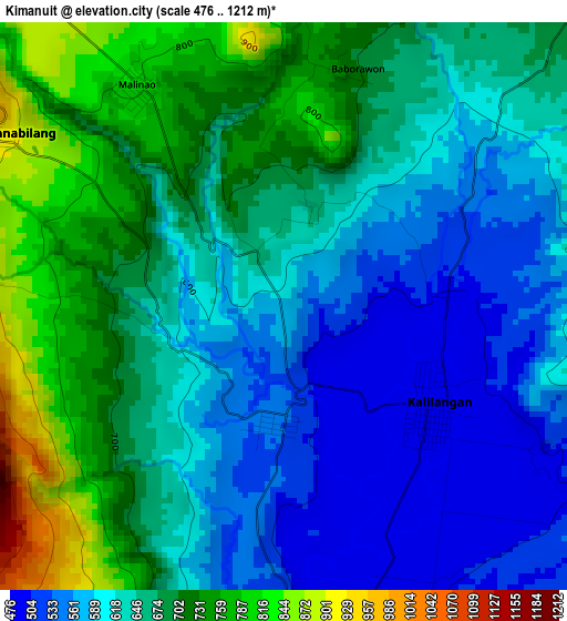
Below is the Elevation map of Kimanuit, which displays elevation range with different colors. Scale of the first map is from 476 to 1212 m (1562 to 3976 ft) with average elevation of 646.9 meters (=2122 ft) [note 1]
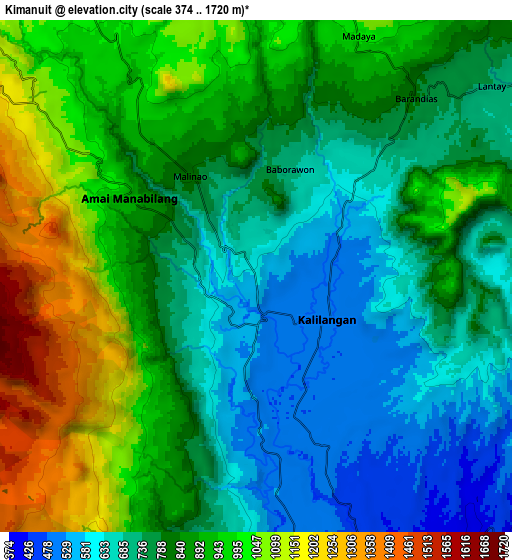
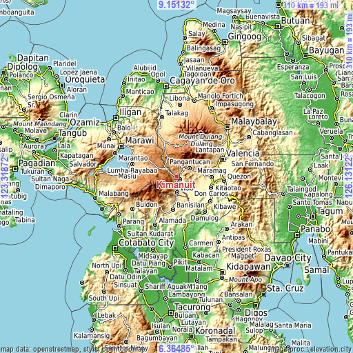
These maps also provides idea of topography and contour of this city, they are displayed at different zoom levels. More info about maps, scale and edge coordinates you can find below images.
| \ | Map #1 | Map #2 | Topo.Map |
| Scale [m] | 476..1212 m | 374..1720 m | × |
| Scale [ft] | 1562..3976 ft | 1227..5643 ft | × |
| Average | 646.9 m = 2122 ft | 834.3 m = 2737 ft | × |
| Width | 9.68 km = 6 mi | 19.37 km = 12 mi | 309.8 km = 192.5 mi |
| Height | 9.68 km = 6 mi | 19.37 km = 12 mi | 309.9 km = 192.6 mi |
| ↑Max Latitude | 7.803931° | 7.847467° | 9.15132° |
| Latitude at center | 7.76039° | 7.76039° | 7.76039° |
| ↓Min Latitude | 7.716845° | 7.673295° | 6.36485° |
| ← Min Longitude | 124.681025° | 124.637079° | 123.31872° |
| Longitude center | 124.72497° | 124.72497° | 124.72497° |
| →Max Longitude | 124.768915° | 124.812861° | 126.13122° |
Nearby cities:
Cities around Kimanuit sort by population:
• Wao elevation 1246 m
10.7 km,  216°
216°
• Kalilangan 874 m
3 km,  124°
124°
• Kadingilan 338 m
26.9 km,  131°
131°
• Banisilan 391 m
30 km,  180°
180°
• San Miguel 1314 m
30.1 km,  6°
6°
• Malinao 516 m
22.3 km, 184°
• Adtugan 650 m
15.4 km,  68°
68°
• Osias 304 m
20.5 km,  150°
150°
• Bangahan 775 m
4.1 km, 13°
• La Roxas 891 m
21.2 km,  57°
57°
• Pangantocan 853 m
13.6 km,  44°
44°
• Bumbaran 1191 m
9.4 km,  298°
298°
Multilingual:
 En español:
Kimanuit elevación 521 m.
 En France:
Kimanuit élévation 521 m.
 Auf Deutsch:
Kimanuit höhe über dem Meeresspiegel ist 521 m.

Sources and notes:
- [note 1] Map square and city borders are not equal. Map elevation data is calculated only from area inside that square.
- [src 1] Elevation data from geonames database provided with same terms of usage.
- [src 2] The elevation map of Kimanuit is generated using elevation data from NASA's 3 arcsec (90m) resolution SRTM data.
- [src 3] Base (background) map © OpenStreetMap contributors tiles are generated by Geofabrik and OpenTopoMap.
Copyright & License:
This Kimanuit Elevation Map is licensed under CC BY-SA. You may reuse any part from this page, if you give a proper credit by linking to this URL:
 More info on terms of use page.