La Roxas elevation
La Roxas (Northern Mindanao, Province of Bukidnon), Philippines elevation is 891 meters and La Roxas elevation in feet is 2923 ft above sea level [src 1]. La Roxas is a populated place (feature code) with elevation that is 803 meters (2635 ft) bigger than average city elevation in Philippines.
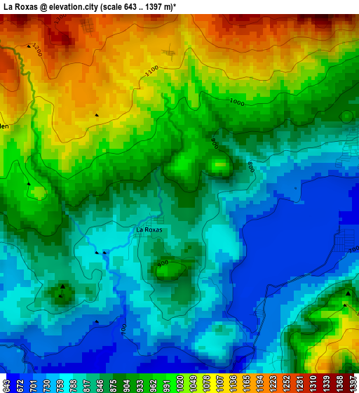
Below is the Elevation map of La Roxas, which displays elevation range with different colors. Scale of the first map is from 643 to 1397 m (2110 to 4583 ft) with average elevation of 908.5 meters (=2981 ft) [note 1]
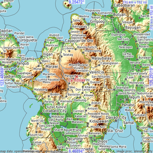
These maps also provides idea of topography and contour of this city, they are displayed at different zoom levels. More info about maps, scale and edge coordinates you can find below images.
| \ | Map #1 | Topo.Map |
| Scale [m] | 643..1397 m | × |
| Scale [ft] | 2110..4583 ft | × |
| Average | 908.5 m = 2981 ft | × |
| Width | 9.68 km = 6 mi | 309.7 km = 192.4 mi |
| Height | 9.68 km = 6 mi | 309.8 km = 192.5 mi |
| ↑Max Latitude | 7.9077° | 9.25472° |
| Latitude at center | 7.86417° | 7.86417° |
| ↓Min Latitude | 7.820636° | 6.46894° |
| ← Min Longitude | 124.842995° | 123.48069° |
| Longitude center | 124.88694° | 124.88694° |
| →Max Longitude | 124.930885° | 126.29319° |
Nearby cities:
Cities around La Roxas sort by population:
• Maramag elevation 276 m
17.2 km,  130°
130°
• Dologon 312 m
17.5 km,  98°
98°
• Kalilangan 874 m
20.3 km,  229°
229°
• Lurugan 862 m
19.1 km,  27°
27°
• Kibangay 1195 m
20.6 km,  1°
1°
• Alanib 820 m
21.2 km, 30°
• Kimanuit 521 m
21.2 km,  237°
237°
• Adtugan 650 m
6.8 km,  211°
211°
• Bangahan 775 m
18.5 km,  245°
245°
• Balila 631 m
20.7 km,  42°
42°
• Basak 1139 m
19.9 km,  352°
352°
• Pangantocan 853 m
8.4 km,  257°
257°
Multilingual:
 En español:
La Roxas elevación 891 m.
 En France:
La Roxas élévation 891 m.
 Auf Deutsch:
La Roxas höhe über dem Meeresspiegel ist 891 m.

Sources and notes:
- [note 1] Map square and city borders are not equal. Map elevation data is calculated only from area inside that square.
- [src 1] Elevation data from geonames database provided with same terms of usage.
- [src 2] The elevation map of La Roxas is generated using elevation data from NASA's 3 arcsec (90m) resolution SRTM data.
- [src 3] Base (background) map © OpenStreetMap contributors tiles are generated by Geofabrik and OpenTopoMap.
Copyright & License:
This La Roxas Elevation Map is licensed under CC BY-SA. You may reuse any part from this page, if you give a proper credit by linking to this URL:
 More info on terms of use page.