Alanib elevation
Alanib (Northern Mindanao, Province of Bukidnon), Philippines elevation is 820 meters and Alanib elevation in feet is 2690 ft above sea level [src 1]. Alanib is a populated place (feature code) with elevation that is 732 meters (2402 ft) bigger than average city elevation in Philippines.
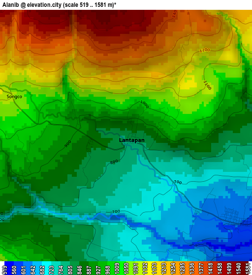
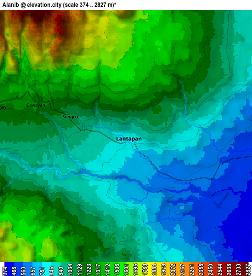
Below is the Elevation map of Alanib, which displays elevation range with different colors. Scale of the first map is from 519 to 1581 m (1703 to 5187 ft) with average elevation of 969.5 meters (=3181 ft) [note 1]
These maps also provides idea of topography and contour of this city, they are displayed at different zoom levels. More info about maps, scale and edge coordinates you can find below images.
| \ | Map #1 | Map #2 | Topo.Map |
| Scale [m] | 519..1581 m | 374..2827 m | × |
| Scale [ft] | 1703..5187 ft | 1227..9275 ft | × |
| Average | 969.5 m = 3181 ft | 1110.9 m = 3645 ft | × |
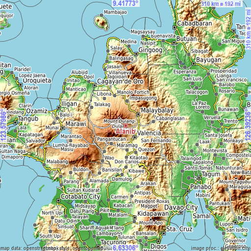
| Width | 9.68 km = 6 mi | 19.35 km = 12 mi | 309.6 km = 192.4 mi |
| Height | 9.68 km = 6 mi | 19.35 km = 12 mi | 309.7 km = 192.4 mi |
| ↑Max Latitude | 8.071292° | 8.1148° | 9.41773° |
| Latitude at center | 8.02778° | 8.02778° | 8.02778° |
| ↓Min Latitude | 7.984263° | 7.940741° | 6.63306° |
| ← Min Longitude | 124.942165° | 124.898219° | 123.57986° |
| Longitude center | 124.98611° | 124.98611° | 124.98611° |
| →Max Longitude | 125.030055° | 125.074001° | 126.39236° |
Nearby cities:
Cities around Alanib sort by population:
• Lurugan elevation 862 m
2.5 km,  240°
240°
• Kibangay 1195 m
10.5 km,  283°
283°
• Aglayan 403 m
16.6 km,  79°
79°
• Mailag 321 m
17.9 km,  110°
110°
• Lantapan 595 m
5.7 km,  126°
126°
• Bantuanon 510 m
9.4 km,  98°
98°
• Bugcaon 449 m
14.1 km, 81°
• San Carlos 383 m
12.6 km, 126°
• Cabangahan 369 m
16.7 km,  91°
91°
• Balila 631 m
4.1 km, 133°
• Basak 1139 m
13.7 km, 276°
• Laguitas 541 m
17.3 km,  66°
66°
Multilingual:
 En español:
Alanib elevación 820 m.
 En France:
Alanib élévation 820 m.


Sources and notes:
- [note 1] Map square and city borders are not equal. Map elevation data is calculated only from area inside that square.
- [src 1] Elevation data from geonames database provided with same terms of usage.
- [src 2] The elevation map of Alanib is generated using elevation data from NASA's 3 arcsec (90m) resolution SRTM data.
- [src 3] Base (background) map © OpenStreetMap contributors tiles are generated by Geofabrik and OpenTopoMap.
Copyright & License:
This Alanib Elevation Map is licensed under CC BY-SA. You may reuse any part from this page, if you give a proper credit by linking to this URL:
 More info on terms of use page.