Aucara elevation
Aucara (Ayacucho, Provincia de Lucanas), Peru elevation is 3221 meters and Aucara elevation in feet is 10568 ft above sea level [src 1]. Aucara is a seat of a third-order administrative division (feature code) with elevation that is 900 meters (2953 ft) bigger than average city elevation in Peru.
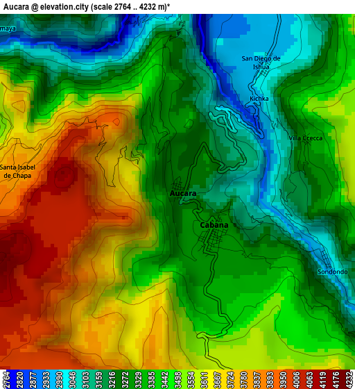
Below is the Elevation map of Aucara, which displays elevation range with different colors. Scale of the first map is from 2764 to 4232 m (9068 to 13885 ft) with average elevation of 3438.6 meters (=11281 ft) [note 1]
These maps also provides idea of topography and contour of this city, they are displayed at different zoom levels. More info about maps, scale and edge coordinates you can find below images.
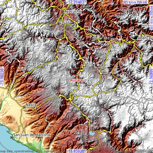
| \ | Map #1 | Topo.Map |
| Scale [m] | 2764..4232 m | × |
| Scale [ft] | 9068..13885 ft | × |
| Average | 3438.6 m = 11281 ft | × |
| Width | 9.47 km = 5.9 mi | 303 km = 188.3 mi |
| Height | 9.47 km = 5.9 mi | 303.1 km = 188.3 mi |
| ↑Max Latitude | -14.238239° | -12.91403° |
| Latitude at center | -14.28083° | -14.28083° |
| ↓Min Latitude | -14.323413° | -15.63938° |
| ← Min Longitude | -74.020055° | -75.38236° |
| Longitude center | -73.97611° | -73.97611° |
| →Max Longitude | -73.932165° | -72.56986° |
Nearby cities:
Cities around Aucara sort by population:
• Lucanas elevation 3472 m
46.1 km,  219°
219°
• Paico 3086 m
44.9 km,  52°
52°
• Soras 3424 m
44.1 km,  65°
65°
• Canaria 3036 m
40.7 km,  10°
10°
• Querobamba 3512 m
33.2 km,  26°
26°
• Apongo 3113 m
30 km, 8°
• Asquipata 3335 m
26.1 km,  15°
15°
• Morcolla 3493 m
22 km, 30°
• Huacaña 3200 m
15.4 km,  39°
39°
• Chipao 3437 m
14.3 km,  131°
131°
• Andamarca 3451 m
11.9 km,  172°
172°
• Cabana 3303 m
1.5 km,  137°
137°
Multilingual:
 En español:
Aucara elevación 3221 m.
 En France:
Aucara élévation 3221 m.


Sources and notes:
- [note 1] Map square and city borders are not equal. Map elevation data is calculated only from area inside that square.
- [src 1] Elevation data from geonames database provided with same terms of usage.
- [src 2] The elevation map of Aucara is generated using elevation data from NASA's 3 arcsec (90m) resolution SRTM data.
- [src 3] Base (background) map © OpenStreetMap contributors tiles are generated by Geofabrik and OpenTopoMap.
Copyright & License:
This Aucara Elevation Map is licensed under CC BY-SA. You may reuse any part from this page, if you give a proper credit by linking to this URL:
 More info on terms of use page.