Querobamba elevation
Querobamba (Ayacucho, Provincia de Sucre), Peru elevation is 3512 meters and Querobamba elevation in feet is 11522 ft above sea level [src 1]. Querobamba is a seat of a third-order administrative division (feature code) with elevation that is 1191 meters (3907 ft) bigger than average city elevation in Peru.
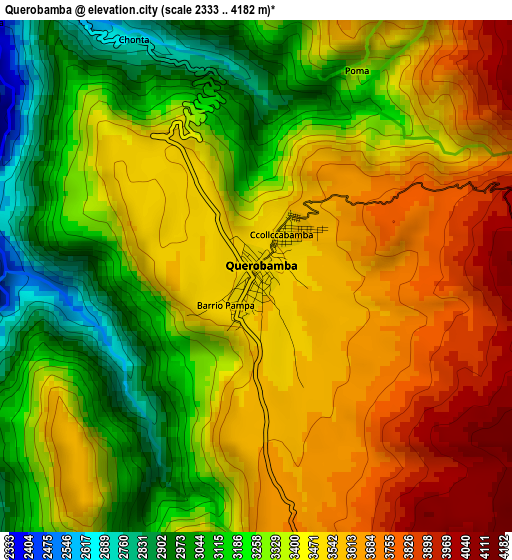
Below is the Elevation map of Querobamba, which displays elevation range with different colors. Scale of the first map is from 2333 to 4182 m (7654 to 13720 ft) with average elevation of 3405.6 meters (=11173 ft) [note 1]
These maps also provides idea of topography and contour of this city, they are displayed at different zoom levels. More info about maps, scale and edge coordinates you can find below images.
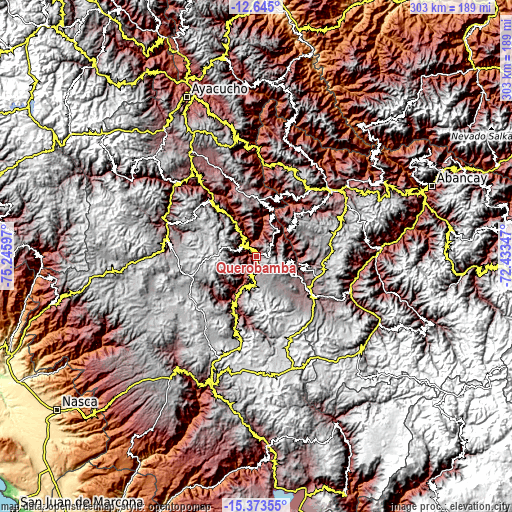
| \ | Map #1 | Topo.Map |
| Scale [m] | 2333..4182 m | × |
| Scale [ft] | 7654..13720 ft | × |
| Average | 3405.6 m = 11173 ft | × |
| Width | 9.48 km = 5.9 mi | 303.4 km = 188.5 mi |
| Height | 9.48 km = 5.9 mi | 303.4 km = 188.5 mi |
| ↑Max Latitude | -13.970689° | -12.645° |
| Latitude at center | -14.01333° | -14.01333° |
| ↓Min Latitude | -14.055964° | -15.37355° |
| ← Min Longitude | -73.883665° | -75.24597° |
| Longitude center | -73.83972° | -73.83972° |
| →Max Longitude | -73.795775° | -72.43347° |
Nearby cities:
Cities around Querobamba sort by population:
• Soras elevation 3424 m
27.8 km,  114°
114°
• Chaccrampa 3657 m
25.6 km,  76°
76°
• Huayana 3207 m
25.1 km,  98°
98°
• Accomarca 3381 m
24.7 km,  343°
343°
• Chiara 3326 m
24.6 km,  49°
49°
• Paico 3086 m
21.3 km, 97°
• Chalcos 3650 m
20.6 km,  26°
26°
• Huacaña 3200 m
18.5 km,  195°
195°
• Canaria 3036 m
12.4 km,  325°
325°
• Morcolla 3493 m
11.3 km, 197°
• Apongo 3113 m
10.1 km,  269°
269°
• Asquipata 3335 m
8.9 km,  238°
238°
Multilingual:
 En español:
Querobamba elevación 3512 m.
 En France:
Querobamba élévation 3512 m.
 Auf Deutsch:
Querobamba höhe über dem Meeresspiegel ist 3512 m.

Sources and notes:
- [note 1] Map square and city borders are not equal. Map elevation data is calculated only from area inside that square.
- [src 1] Elevation data from geonames database provided with same terms of usage.
- [src 2] The elevation map of Querobamba is generated using elevation data from NASA's 3 arcsec (90m) resolution SRTM data.
- [src 3] Base (background) map © OpenStreetMap contributors tiles are generated by Geofabrik and OpenTopoMap.
Copyright & License:
This Querobamba Elevation Map is licensed under CC BY-SA. You may reuse any part from this page, if you give a proper credit by linking to this URL:
 More info on terms of use page.