Lucanas elevation
Lucanas (Ayacucho, Provincia de Lucanas), Peru elevation is 3472 meters and Lucanas elevation in feet is 11391 ft above sea level [src 1]. Lucanas is a seat of a third-order administrative division (feature code) with elevation that is 1151 meters (3776 ft) bigger than average city elevation in Peru.
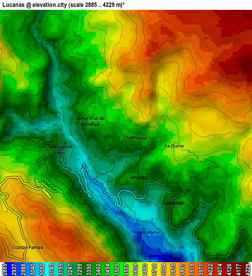
Below is the Elevation map of Lucanas, which displays elevation range with different colors. Scale of the first map is from 2885 to 4229 m (9465 to 13875 ft) with average elevation of 3552.5 meters (=11655 ft) [note 1]
These maps also provides idea of topography and contour of this city, they are displayed at different zoom levels. More info about maps, scale and edge coordinates you can find below images.
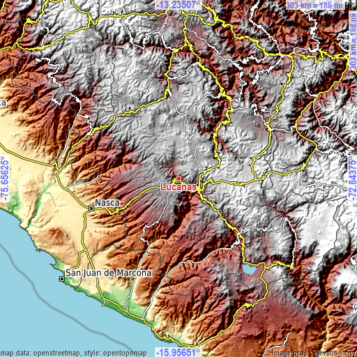
| \ | Map #1 | Topo.Map |
| Scale [m] | 2885..4229 m | × |
| Scale [ft] | 9465..13875 ft | × |
| Average | 3552.5 m = 11655 ft | × |
| Width | 9.46 km = 5.9 mi | 302.6 km = 188 mi |
| Height | 9.46 km = 5.9 mi | 302.6 km = 188 mi |
| ↑Max Latitude | -14.55747° | -13.23507° |
| Latitude at center | -14.6° | -14.6° |
| ↓Min Latitude | -14.642522° | -15.95651° |
| ← Min Longitude | -74.293945° | -75.65625° |
| Longitude center | -74.25° | -74.25° |
| →Max Longitude | -74.206055° | -72.84375° |
Nearby cities:
Cities around Lucanas sort by population:
• Puquio elevation 3195 m
16.8 km,  131°
131°
• Tambo 4133 m
41.4 km,  122°
122°
• Chaviña 3224 m
61.8 km, 133°
• Huacaña 3200 m
61.5 km,  39°
39°
• Otoca 2288 m
50.1 km,  284°
284°
• Tambo Quemado 2622 m
48.9 km,  252°
252°
• Chipao 3437 m
47.9 km,  57°
57°
• Aucara 3221 m
46.1 km, 39°
• Cabana 3303 m
46 km, 41°
• Andamarca 3451 m
39.1 km,  52°
52°
• San Pedro 3105 m
24.6 km,  138°
138°
• San Juan 3281 m
7.7 km, 135°
Multilingual:
 En español:
Lucanas elevación 3472 m.
 En France:
Lucanas élévation 3472 m.
 Auf Deutsch:
Lucanas höhe über dem Meeresspiegel ist 3472 m.

Sources and notes:
- [note 1] Map square and city borders are not equal. Map elevation data is calculated only from area inside that square.
- [src 1] Elevation data from geonames database provided with same terms of usage.
- [src 2] The elevation map of Lucanas is generated using elevation data from NASA's 3 arcsec (90m) resolution SRTM data.
- [src 3] Base (background) map © OpenStreetMap contributors tiles are generated by Geofabrik and OpenTopoMap.
Copyright & License:
This Lucanas Elevation Map is licensed under CC BY-SA. You may reuse any part from this page, if you give a proper credit by linking to this URL:
 More info on terms of use page.