Acarí elevation
Acarí (Arequipa, Provincia de Caravelí), Peru elevation is 167 meters and Acarí elevation in feet is 548 ft above sea level [src 1]. Acarí is a populated place (feature code) with elevation that is 2154 meters (7067 ft) smaller than average city elevation in Peru.
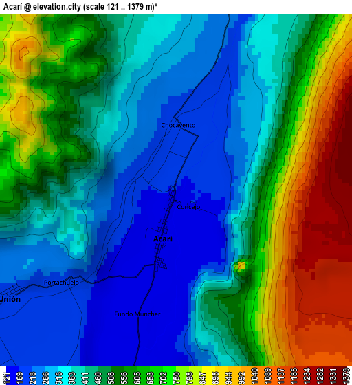
Below is the Elevation map of Acarí, which displays elevation range with different colors. Scale of the first map is from 121 to 1379 m (397 to 4524 ft) with average elevation of 498.7 meters (=1636 ft) [note 1]
These maps also provides idea of topography and contour of this city, they are displayed at different zoom levels. More info about maps, scale and edge coordinates you can find below images.
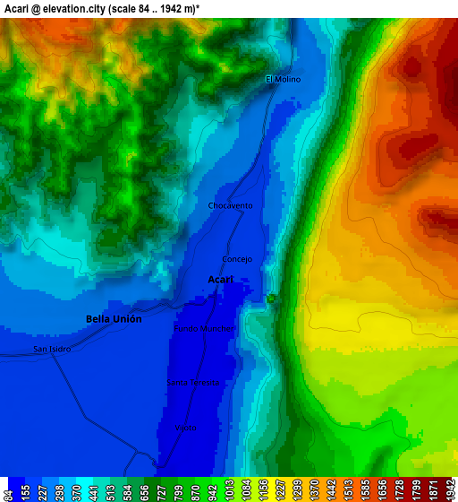
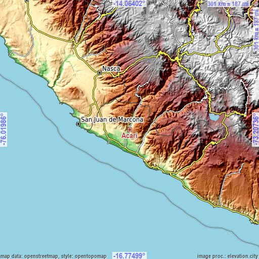
| \ | Map #1 | Map #2 | Topo.Map |
| Scale [m] | 121..1379 m | 84..1942 m | × |
| Scale [ft] | 397..4524 ft | 276..6371 ft | × |
| Average | 498.7 m = 1636 ft | 721.9 m = 2368 ft | × |
| Width | 9.42 km = 5.9 mi | 18.84 km = 11.7 mi | 301.4 km = 187.3 mi |
| Height | 9.42 km = 5.9 mi | 18.84 km = 11.7 mi | 301.5 km = 187.3 mi |
| ↑Max Latitude | -15.381563° | -15.339188° | -14.06402° |
| Latitude at center | -15.42393° | -15.42393° | -15.42393° |
| ↓Min Latitude | -15.466288° | -15.508638° | -16.77499° |
| ← Min Longitude | -74.657555° | -74.701501° | -76.01986° |
| Longitude center | -74.61361° | -74.61361° | -74.61361° |
| →Max Longitude | -74.569665° | -74.525719° | -73.20736° |
Nearby cities:
Cities around Acarí sort by population:
• Nazca elevation 584 m
74.6 km,  332°
332°
• Minas de Marcona 776 m
58.2 km,  293°
293°
• San Pedro 3105 m
91.5 km,  37°
37°
• Quicacha 1808 m
90.2 km,  104°
104°
• Pullo 3046 m
88.5 km,  74°
74°
• Achanizo 619 m
81.2 km,  121°
121°
• Tambo Quemado 2622 m
77.2 km,  354°
354°
• Chala 20 m
62.9 km,  141°
141°
• Tocota 963 m
61.8 km, 115°
• San Juan de Marcona 23 m
59.2 km,  276°
276°
• Atiquipa 310 m
49.3 km,  147°
147°
• Yauca 27 m
27.9 km,  160°
160°
Multilingual:
 En español:
Acarí elevación 167 m.
 En France:
Acarí élévation 167 m.


Sources and notes:
- [note 1] Map square and city borders are not equal. Map elevation data is calculated only from area inside that square.
- [src 1] Elevation data from geonames database provided with same terms of usage.
- [src 2] The elevation map of Acarí is generated using elevation data from NASA's 3 arcsec (90m) resolution SRTM data.
- [src 3] Base (background) map © OpenStreetMap contributors tiles are generated by Geofabrik and OpenTopoMap.
Copyright & License:
This Acarí Elevation Map is licensed under CC BY-SA. You may reuse any part from this page, if you give a proper credit by linking to this URL:
 More info on terms of use page.