Nazca elevation
Nazca (Ica, Provincia de Nazca), Peru elevation is 584 meters and Nazca elevation in feet is 1916 ft above sea level [src 1]. Nazca is a seat of a third-order administrative division (feature code) with elevation that is 1737 meters (5699 ft) smaller than average city elevation in Peru.
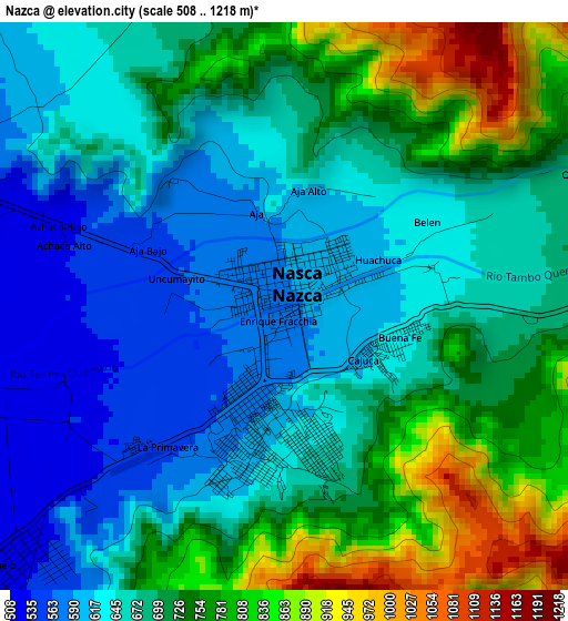
Below is the Elevation map of Nazca, which displays elevation range with different colors. Scale of the first map is from 508 to 1218 m (1667 to 3996 ft) with average elevation of 694 meters (=2277 ft) [note 1]
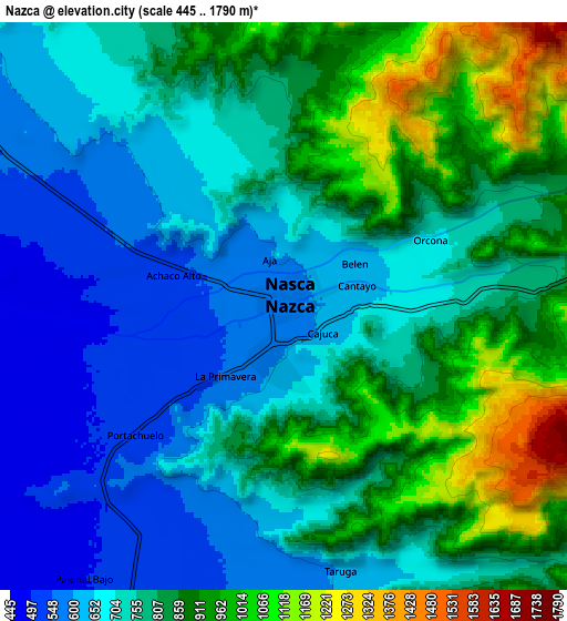
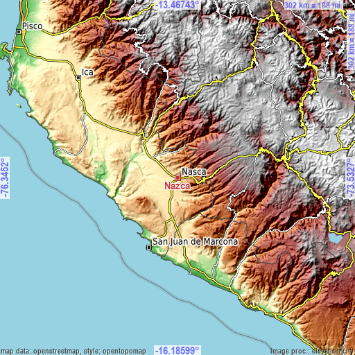
These maps also provides idea of topography and contour of this city, they are displayed at different zoom levels. More info about maps, scale and edge coordinates you can find below images.
| \ | Map #1 | Map #2 | Topo.Map |
| Scale [m] | 508..1218 m | 445..1790 m | × |
| Scale [ft] | 1667..3996 ft | 1460..5873 ft | × |
| Average | 694 m = 2277 ft | 780.2 m = 2560 ft | × |
| Width | 9.45 km = 5.9 mi | 18.89 km = 11.7 mi | 302.3 km = 187.8 mi |
| Height | 9.45 km = 5.9 mi | 18.89 km = 11.7 mi | 302.3 km = 187.8 mi |
| ↑Max Latitude | -14.788495° | -14.746001° | -13.46743° |
| Latitude at center | -14.83098° | -14.83098° | -14.83098° |
| ↓Min Latitude | -14.873457° | -14.915926° | -16.18599° |
| ← Min Longitude | -74.982895° | -75.026841° | -76.3452° |
| Longitude center | -74.93895° | -74.93895° | -74.93895° |
| →Max Longitude | -74.895005° | -74.851059° | -73.5327° |
Nearby cities:
Cities around Nazca sort by population:
• Minas de Marcona elevation 776 m
46.2 km,  203°
203°
• Palpa 349 m
42.4 km,  321°
321°
• Río Grande 372 m
44.8 km, 321°
• Laramate 3559 m
65.1 km,  6°
6°
• San Juan de Marcona 23 m
64.1 km, 201°
• Llauta 2994 m
62.8 km,  2°
2°
• Ocaña 2942 m
51.5 km, 14°
• Otoca 2288 m
46.4 km,  33°
33°
• Llipata 312 m
41.4 km, 315°
• Changuillo 248 m
35.8 km,  301°
301°
• Tambo Quemado 2622 m
29.5 km,  68°
68°
• El Ingenio 451 m
24.3 km,  328°
328°
Multilingual:
 En español:
Provincia de Nazca elevación 584 m.
 En France:
Nazca élévation 584 m.


Sources and notes:
- [note 1] Map square and city borders are not equal. Map elevation data is calculated only from area inside that square.
- [src 1] Elevation data from geonames database provided with same terms of usage.
- [src 2] The elevation map of Nazca is generated using elevation data from NASA's 3 arcsec (90m) resolution SRTM data.
- [src 3] Base (background) map © OpenStreetMap contributors tiles are generated by Geofabrik and OpenTopoMap.
Copyright & License:
This Nazca Elevation Map is licensed under CC BY-SA. You may reuse any part from this page, if you give a proper credit by linking to this URL:
 More info on terms of use page.