Quicacha elevation
Quicacha (Arequipa, Provincia de Caravelí), Peru elevation is 1808 meters and Quicacha elevation in feet is 5932 ft above sea level [src 1]. Quicacha is a seat of a third-order administrative division (feature code) with elevation that is 513 meters (1683 ft) smaller than average city elevation in Peru.
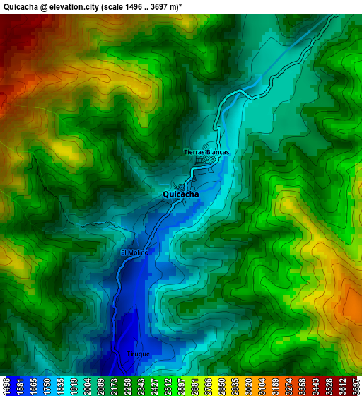
Below is the Elevation map of Quicacha, which displays elevation range with different colors. Scale of the first map is from 1496 to 3697 m (4908 to 12129 ft) with average elevation of 2308.9 meters (=7575 ft) [note 1]
These maps also provides idea of topography and contour of this city, they are displayed at different zoom levels. More info about maps, scale and edge coordinates you can find below images.
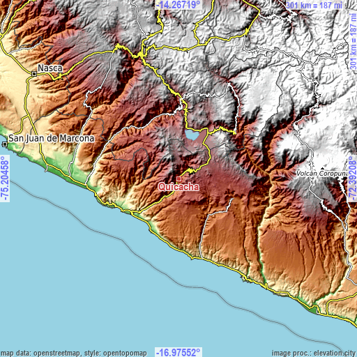
| \ | Map #1 | Topo.Map |
| Scale [m] | 1496..3697 m | × |
| Scale [ft] | 4908..12129 ft | × |
| Average | 2308.9 m = 7575 ft | × |
| Width | 9.41 km = 5.8 mi | 301.1 km = 187.1 mi |
| Height | 9.41 km = 5.8 mi | 301.2 km = 187.2 mi |
| ↑Max Latitude | -15.583504° | -14.26719° |
| Latitude at center | -15.62583° | -15.62583° |
| ↓Min Latitude | -15.668147° | -16.97552° |
| ← Min Longitude | -73.842275° | -75.20458° |
| Longitude center | -73.79833° | -73.79833° |
| →Max Longitude | -73.754385° | -72.39208° |
Nearby cities:
Cities around Quicacha sort by population:
• Coracora elevation 3219 m
65.9 km,  1°
1°
• Tauria 2886 m
67.6 km,  63°
63°
• Atiquipa 310 m
63.4 km,  252°
252°
• Pausa 2516 m
61.9 km,  51°
51°
• Chumpi 3019 m
58.6 km, 3°
• Quilcata 3374 m
55.9 km,  41°
41°
• Chala 20 m
54.9 km,  240°
240°
• Incuyo 3295 m
47.7 km,  28°
28°
• Pullo 3046 m
45.5 km,  357°
357°
• Cahuacho 3406 m
36.7 km,  68°
68°
• Tocota 963 m
31.5 km,  263°
263°
• Achanizo 619 m
27 km,  221°
221°
Multilingual:
 En español:
Quicacha elevación 1808 m.
 En France:
Quicacha élévation 1808 m.
 Auf Deutsch:
Quicacha höhe über dem Meeresspiegel ist 1808 m.

Sources and notes:
- [note 1] Map square and city borders are not equal. Map elevation data is calculated only from area inside that square.
- [src 1] Elevation data from geonames database provided with same terms of usage.
- [src 2] The elevation map of Quicacha is generated using elevation data from NASA's 3 arcsec (90m) resolution SRTM data.
- [src 3] Base (background) map © OpenStreetMap contributors tiles are generated by Geofabrik and OpenTopoMap.
Copyright & License:
This Quicacha Elevation Map is licensed under CC BY-SA. You may reuse any part from this page, if you give a proper credit by linking to this URL:
 More info on terms of use page.