Andahuaylillas elevation
Andahuaylillas (Cusco, Provincia de Quispicanchis), Peru elevation is 3123 meters and Andahuaylillas elevation in feet is 10246 ft above sea level [src 1]. Andahuaylillas is a seat of a third-order administrative division (feature code) with elevation that is 802 meters (2631 ft) bigger than average city elevation in Peru.
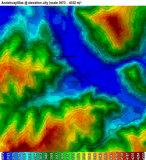
Below is the Elevation map of Andahuaylillas, which displays elevation range with different colors. Scale of the first map is from 3073 to 4332 m (10082 to 14213 ft) with average elevation of 3520.4 meters (=11550 ft) [note 1]
These maps also provides idea of topography and contour of this city, they are displayed at different zoom levels. More info about maps, scale and edge coordinates you can find below images.
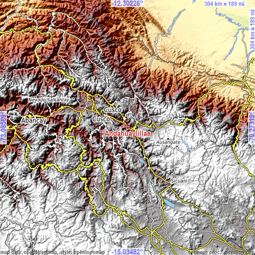
| \ | Map #1 | Topo.Map |
| Scale [m] | 3073..4332 m | × |
| Scale [ft] | 10082..14213 ft | × |
| Average | 3520.4 m = 11550 ft | × |
| Width | 9.5 km = 5.9 mi | 303.8 km = 188.8 mi |
| Height | 9.5 km = 5.9 mi | 303.9 km = 188.8 mi |
| ↑Max Latitude | -13.629796° | -12.30226° |
| Latitude at center | -13.6725° | -13.6725° |
| ↓Min Latitude | -13.715196° | -15.03482° |
| ← Min Longitude | -71.723385° | -73.08569° |
| Longitude center | -71.67944° | -71.67944° |
| →Max Longitude | -71.635495° | -70.27319° |
Nearby cities:
Cities around Andahuaylillas sort by population:
• Urcos elevation 3127 m
6.3 km,  103°
103°
• Oropesa 3096 m
13.4 km,  311°
311°
• Yaurisque 3324 m
26.1 km,  271°
271°
• Colcha 2809 m
24 km,  213°
213°
• Quiquijana 3233 m
22.5 km,  137°
137°
• San Salvador 3105 m
22.4 km,  332°
332°
• Saylla 3229 m
22.1 km,  304°
304°
• Paruro 3112 m
21 km,  241°
241°
• Ccatca 3765 m
15 km,  59°
59°
• Caicay 3102 m
8.9 km,  345°
345°
• Lucre 3104 m
7.5 km, 303°
• Huaro 3192 m
5 km,  110°
110°
Multilingual:
 En español:
Andahuaylillas elevación 3123 m.
 En France:
Andahuaylillas élévation 3123 m.
 Auf Deutsch:
Andahuaylillas höhe über dem Meeresspiegel ist 3123 m.

Sources and notes:
- [note 1] Map square and city borders are not equal. Map elevation data is calculated only from area inside that square.
- [src 1] Elevation data from geonames database provided with same terms of usage.
- [src 2] The elevation map of Andahuaylillas is generated using elevation data from NASA's 3 arcsec (90m) resolution SRTM data.
- [src 3] Base (background) map © OpenStreetMap contributors tiles are generated by Geofabrik and OpenTopoMap.
Copyright & License:
This Andahuaylillas Elevation Map is licensed under CC BY-SA. You may reuse any part from this page, if you give a proper credit by linking to this URL:
 More info on terms of use page.