San Salvador elevation
San Salvador (Cusco, Provincia de Calca), Peru elevation is 3105 meters and San Salvador elevation in feet is 10187 ft above sea level [src 1]. San Salvador is a seat of a third-order administrative division (feature code) with elevation that is 784 meters (2572 ft) bigger than average city elevation in Peru.
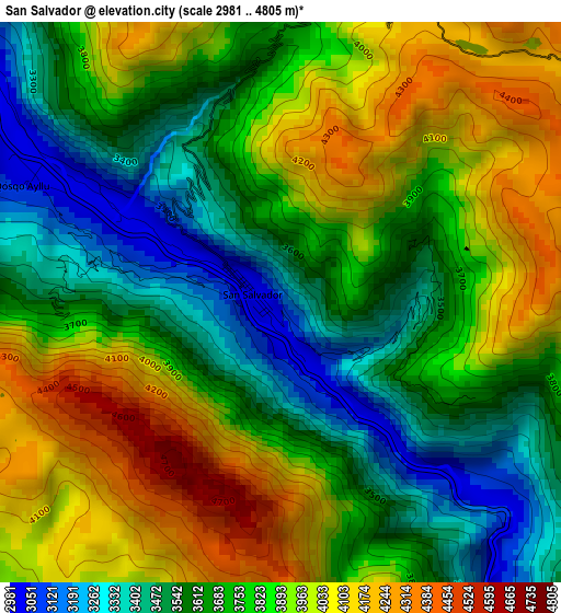
Below is the Elevation map of San Salvador, which displays elevation range with different colors. Scale of the first map is from 2981 to 4805 m (9780 to 15764 ft) with average elevation of 3775.2 meters (=12386 ft) [note 1]
These maps also provides idea of topography and contour of this city, they are displayed at different zoom levels. More info about maps, scale and edge coordinates you can find below images.
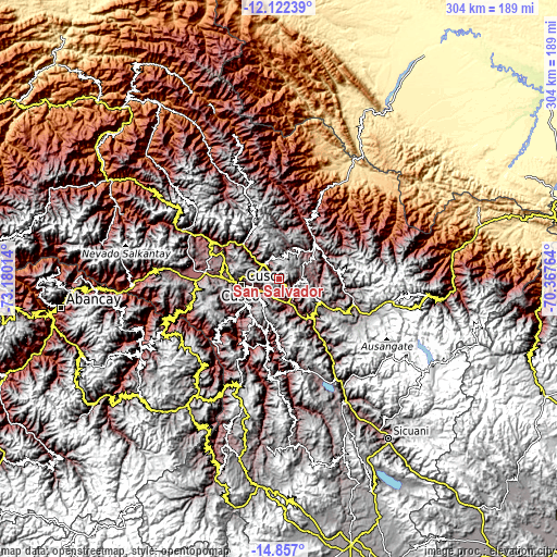
| \ | Map #1 | Topo.Map |
| Scale [m] | 2981..4805 m | × |
| Scale [ft] | 9780..15764 ft | × |
| Average | 3775.2 m = 12386 ft | × |
| Width | 9.5 km = 5.9 mi | 304.1 km = 189 mi |
| Height | 9.5 km = 5.9 mi | 304.1 km = 189 mi |
| ↑Max Latitude | -13.450874° | -12.12239° |
| Latitude at center | -13.49361° | -13.49361° |
| ↓Min Latitude | -13.536338° | -14.857° |
| ← Min Longitude | -71.817835° | -73.18014° |
| Longitude center | -71.77389° | -71.77389° |
| →Max Longitude | -71.729945° | -70.36764° |
Nearby cities:
Cities around San Salvador sort by population:
• Cusco elevation 3369 m
21.2 km,  261°
261°
• Oropesa 3096 m
11 km,  178°
178°
• Pisac 2970 m
11.2 km,  315°
315°
• Yaurisque 3324 m
25 km,  219°
219°
• Andahuaylillas 3123 m
22.4 km,  152°
152°
• Lamay 2932 m
21.7 km,  311°
311°
• Colquepata 3592 m
19 km,  36°
36°
• Coya 2946 m
18 km, 310°
• Lucre 3104 m
16.3 km,  166°
166°
• Caicay 3102 m
13.9 km,  144°
144°
• Taray 2978 m
12.5 km, 305°
• Saylla 3229 m
11.1 km,  227°
227°
Multilingual:
 En español:
San Salvador elevación 3105 m.
 En France:
San Salvador élévation 3105 m.
 Auf Deutsch:
San Salvador höhe über dem Meeresspiegel ist 3105 m.

Sources and notes:
- [note 1] Map square and city borders are not equal. Map elevation data is calculated only from area inside that square.
- [src 1] Elevation data from geonames database provided with same terms of usage.
- [src 2] The elevation map of San Salvador is generated using elevation data from NASA's 3 arcsec (90m) resolution SRTM data.
- [src 3] Base (background) map © OpenStreetMap contributors tiles are generated by Geofabrik and OpenTopoMap.
Copyright & License:
This San Salvador Elevation Map is licensed under CC BY-SA. You may reuse any part from this page, if you give a proper credit by linking to this URL:
 More info on terms of use page.