Yaurisque elevation
Yaurisque (Cusco, Provincia de Paruro), Peru elevation is 3324 meters and Yaurisque elevation in feet is 10906 ft above sea level [src 1]. Yaurisque is a seat of a third-order administrative division (feature code) with elevation that is 1003 meters (3291 ft) bigger than average city elevation in Peru.
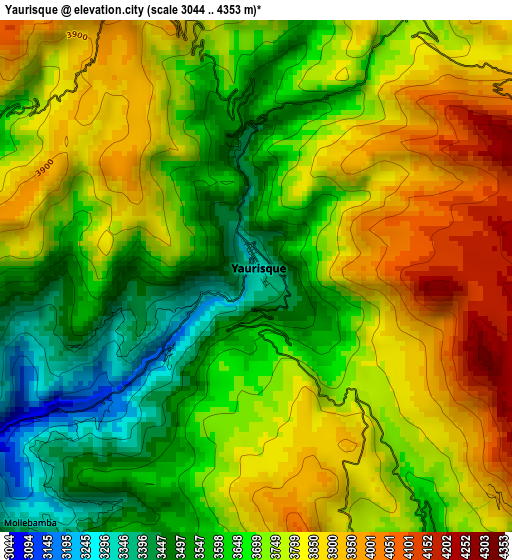
Below is the Elevation map of Yaurisque, which displays elevation range with different colors. Scale of the first map is from 3044 to 4353 m (9987 to 14281 ft) with average elevation of 3725.1 meters (=12221 ft) [note 1]
These maps also provides idea of topography and contour of this city, they are displayed at different zoom levels. More info about maps, scale and edge coordinates you can find below images.
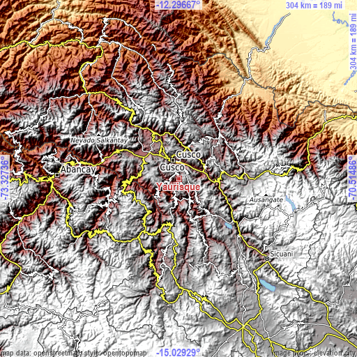
| \ | Map #1 | Topo.Map |
| Scale [m] | 3044..4353 m | × |
| Scale [ft] | 9987..14281 ft | × |
| Average | 3725.1 m = 12221 ft | × |
| Width | 9.5 km = 5.9 mi | 303.8 km = 188.8 mi |
| Height | 9.5 km = 5.9 mi | 303.9 km = 188.8 mi |
| ↑Max Latitude | -13.624235° | -12.29667° |
| Latitude at center | -13.66694° | -13.66694° |
| ↓Min Latitude | -13.709637° | -15.02929° |
| ← Min Longitude | -71.965055° | -73.32736° |
| Longitude center | -71.92111° | -71.92111° |
| →Max Longitude | -71.877165° | -70.51486° |
Nearby cities:
Cities around Yaurisque sort by population:
• Cusco elevation 3369 m
16.8 km,  342°
342°
• Oropesa 3096 m
18.1 km,  62°
62°
• Caicay 3102 m
25.3 km,  71°
71°
• San Salvador 3105 m
25 km,  39°
39°
• Colcha 2809 m
24.2 km,  148°
148°
• Poroy 3490 m
23.2 km,  325°
325°
• Lucre 3104 m
20.1 km,  80°
80°
• Ccorca 3630 m
17.5 km,  301°
301°
• Saylla 3229 m
14.1 km,  33°
33°
• Paruro 3112 m
13.2 km,  144°
144°
• Paccaritambo 3621 m
10.9 km,  199°
199°
• Huanoquite 3388 m
10.5 km,  260°
260°
Multilingual:
 En español:
Yaurisque elevación 3324 m.
 En France:
Yaurisque élévation 3324 m.
 Auf Deutsch:
Yaurisque höhe über dem Meeresspiegel ist 3324 m.

Sources and notes:
- [note 1] Map square and city borders are not equal. Map elevation data is calculated only from area inside that square.
- [src 1] Elevation data from geonames database provided with same terms of usage.
- [src 2] The elevation map of Yaurisque is generated using elevation data from NASA's 3 arcsec (90m) resolution SRTM data.
- [src 3] Base (background) map © OpenStreetMap contributors tiles are generated by Geofabrik and OpenTopoMap.
Copyright & License:
This Yaurisque Elevation Map is licensed under CC BY-SA. You may reuse any part from this page, if you give a proper credit by linking to this URL:
 More info on terms of use page.