El Descanso elevation
El Descanso (Cusco, Provincia de Canas), Peru elevation is 3961 meters and El Descanso elevation in feet is 12995 ft above sea level [src 1]. El Descanso is a seat of a third-order administrative division (feature code) with elevation that is 1640 meters (5381 ft) bigger than average city elevation in Peru.
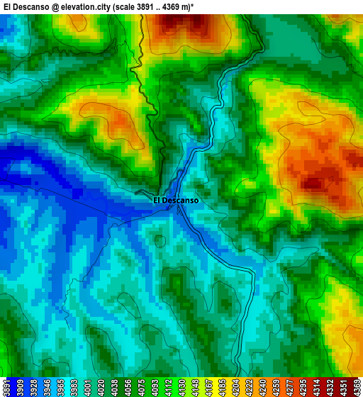
Below is the Elevation map of El Descanso, which displays elevation range with different colors. Scale of the first map is from 3891 to 4369 m (12766 to 14334 ft) with average elevation of 4052.3 meters (=13295 ft) [note 1]
These maps also provides idea of topography and contour of this city, they are displayed at different zoom levels. More info about maps, scale and edge coordinates you can find below images.
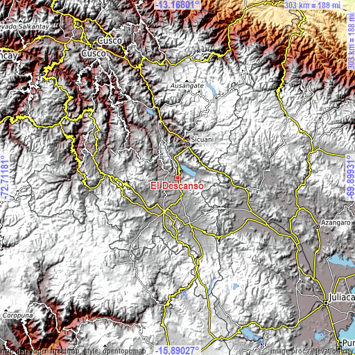
| \ | Map #1 | Topo.Map |
| Scale [m] | 3891..4369 m | × |
| Scale [ft] | 12766..14334 ft | × |
| Average | 4052.3 m = 13295 ft | × |
| Width | 9.46 km = 5.9 mi | 302.7 km = 188.1 mi |
| Height | 9.46 km = 5.9 mi | 302.7 km = 188.1 mi |
| ↑Max Latitude | -14.490787° | -13.16801° |
| Latitude at center | -14.53333° | -14.53333° |
| ↓Min Latitude | -14.575865° | -15.89027° |
| ← Min Longitude | -71.349505° | -72.71181° |
| Longitude center | -71.30556° | -71.30556° |
| →Max Longitude | -71.261615° | -69.89931° |
Nearby cities:
Cities around El Descanso sort by population:
• Sicuani elevation 3551 m
30.6 km,  16°
16°
• Ccaquiracunca 4081 m
32.5 km,  331°
331°
• Layo 3985 m
16.8 km,  74°
74°
• Conchopata 3973 m
13.5 km,  58°
58°
• Langui 3967 m
11.8 km, 17°
• Cahuanuyo 3892 m
27.3 km,  321°
321°
• Chignayhua 3917 m
35.3 km, 334°
• Checca 3820 m
11.7 km,  305°
305°
• Maranganí 3701 m
24.5 km,  36°
36°
• Accocunca 4032 m
26.8 km,  168°
168°
• Quehue 3805 m
23.4 km, 316°
• Pichigua 3866 m
20.4 km,  216°
216°
Multilingual:
 En español:
El Descanso elevación 3961 m.
 En France:
El Descanso élévation 3961 m.
 Auf Deutsch:
El Descanso höhe über dem Meeresspiegel ist 3961 m.

Sources and notes:
- [note 1] Map square and city borders are not equal. Map elevation data is calculated only from area inside that square.
- [src 1] Elevation data from geonames database provided with same terms of usage.
- [src 2] The elevation map of El Descanso is generated using elevation data from NASA's 3 arcsec (90m) resolution SRTM data.
- [src 3] Base (background) map © OpenStreetMap contributors tiles are generated by Geofabrik and OpenTopoMap.
Copyright & License:
This El Descanso Elevation Map is licensed under CC BY-SA. You may reuse any part from this page, if you give a proper credit by linking to this URL:
 More info on terms of use page.