Ccaquiracunca elevation
Ccaquiracunca (Cusco, Provincia de Canas), Peru elevation is 4081 meters and Ccaquiracunca elevation in feet is 13389 ft above sea level [src 1]. Ccaquiracunca is a populated place (feature code) with elevation that is 1760 meters (5774 ft) bigger than average city elevation in Peru.
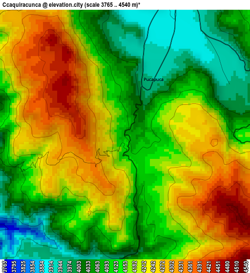
Below is the Elevation map of Ccaquiracunca, which displays elevation range with different colors. Scale of the first map is from 3765 to 4540 m (12352 to 14895 ft) with average elevation of 4159.7 meters (=13647 ft) [note 1]
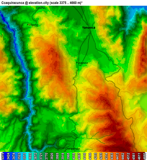
These maps also provides idea of topography and contour of this city, they are displayed at different zoom levels. More info about maps, scale and edge coordinates you can find below images.
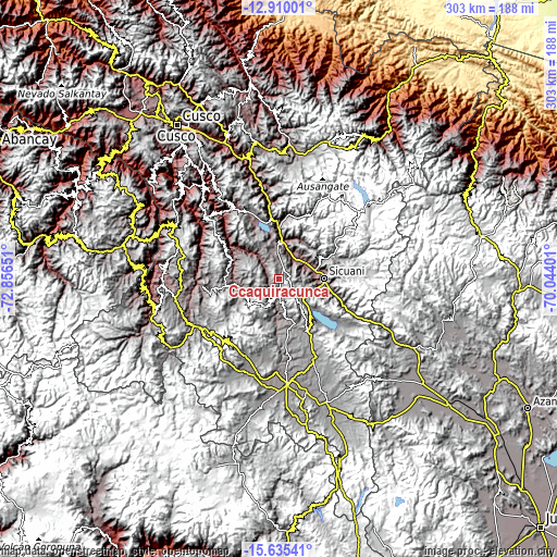
| \ | Map #1 | Map #2 | Topo.Map |
| Scale [m] | 3765..4540 m | 3375..4660 m | × |
| Scale [ft] | 12352..14895 ft | 11073..15289 ft | × |
| Average | 4159.7 m = 13647 ft | 4059.4 m = 13318 ft | × |
| Width | 9.47 km = 5.9 mi | 18.94 km = 11.8 mi | 303 km = 188.3 mi |
| Height | 9.47 km = 5.9 mi | 18.94 km = 11.8 mi | 303.1 km = 188.3 mi |
| ↑Max Latitude | -14.234238° | -14.191638° | -12.91001° |
| Latitude at center | -14.27683° | -14.27683° | -14.27683° |
| ↓Min Latitude | -14.319414° | -14.36199° | -15.63541° |
| ← Min Longitude | -71.494205° | -71.538151° | -72.85651° |
| Longitude center | -71.45026° | -71.45026° | -71.45026° |
| →Max Longitude | -71.406315° | -71.362369° | -70.04401° |
Nearby cities:
Cities around Ccaquiracunca sort by population:
• Cahuanuyo elevation 3892 m
7.3 km,  190°
190°
• Yanaoca 3912 m
6.8 km,  17°
17°
• Chignayhua 3917 m
3.5 km,  10°
10°
• Pampamarca 3819 m
14.5 km,  356°
356°
• Mosoc Llacta 3805 m
17.6 km,  352°
352°
• Tungasuca 3793 m
12.9 km, 347°
• Ccuntuma 3484 m
17.3 km, 13°
• Queromarca 3497 m
12.6 km,  34°
34°
• San Pablo 3488 m
16.7 km,  60°
60°
• Tinta 3484 m
15.4 km, 17°
• San Pedro 3485 m
15.4 km,  49°
49°
• Quehue 3805 m
11.5 km,  182°
182°
Multilingual:
 En español:
Ccaquiracunca elevación 4081 m.
 En France:
Ccaquiracunca élévation 4081 m.
 Auf Deutsch:
Ccaquiracunca höhe über dem Meeresspiegel ist 4081 m.

Sources and notes:
- [note 1] Map square and city borders are not equal. Map elevation data is calculated only from area inside that square.
- [src 1] Elevation data from geonames database provided with same terms of usage.
- [src 2] The elevation map of Ccaquiracunca is generated using elevation data from NASA's 3 arcsec (90m) resolution SRTM data.
- [src 3] Base (background) map © OpenStreetMap contributors tiles are generated by Geofabrik and OpenTopoMap.
Copyright & License:
This Ccaquiracunca Elevation Map is licensed under CC BY-SA. You may reuse any part from this page, if you give a proper credit by linking to this URL:
 More info on terms of use page.