San Pedro elevation
San Pedro (Cusco, Provincia de Canchis), Peru elevation is 3485 meters and San Pedro elevation in feet is 11434 ft above sea level [src 1]. San Pedro is a seat of a third-order administrative division (feature code) with elevation that is 1164 meters (3819 ft) bigger than average city elevation in Peru.
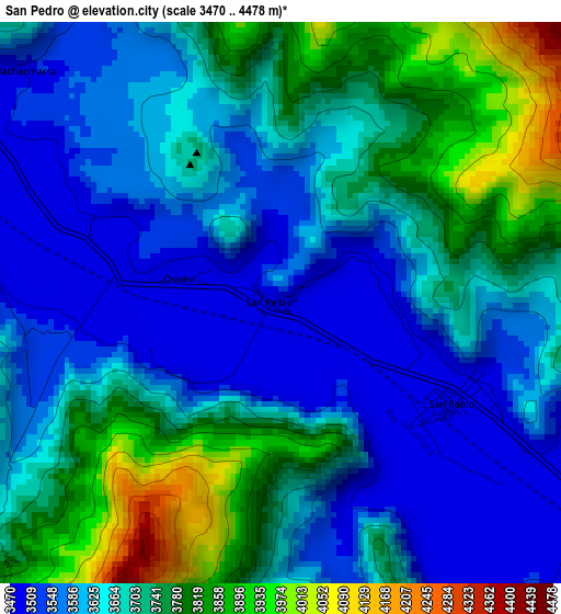
Below is the Elevation map of San Pedro, which displays elevation range with different colors. Scale of the first map is from 3470 to 4478 m (11385 to 14692 ft) with average elevation of 3670.9 meters (=12044 ft) [note 1]
These maps also provides idea of topography and contour of this city, they are displayed at different zoom levels. More info about maps, scale and edge coordinates you can find below images.
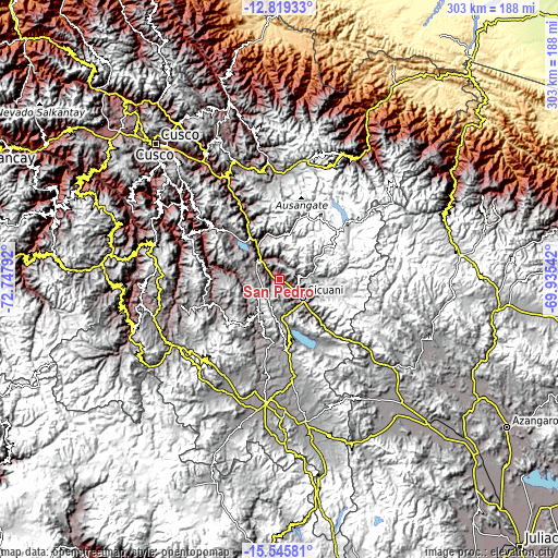
| \ | Map #1 | Topo.Map |
| Scale [m] | 3470..4478 m | × |
| Scale [ft] | 11385..14692 ft | × |
| Average | 3670.9 m = 12044 ft | × |
| Width | 9.47 km = 5.9 mi | 303.2 km = 188.4 mi |
| Height | 9.47 km = 5.9 mi | 303.2 km = 188.4 mi |
| ↑Max Latitude | -14.144061° | -12.81933° |
| Latitude at center | -14.18667° | -14.18667° |
| ↓Min Latitude | -14.229271° | -15.54581° |
| ← Min Longitude | -71.385615° | -72.74792° |
| Longitude center | -71.34167° | -71.34167° |
| →Max Longitude | -71.297725° | -69.93542° |
Nearby cities:
Cities around San Pedro sort by population:
• Yanaoca elevation 3912 m
10.3 km,  250°
250°
• Chignayhua 3917 m
12.9 km,  239°
239°
• Pampamarca 3819 m
13.5 km,  289°
289°
• Tungasuca 3793 m
14.8 km,  279°
279°
• Cullcuyre 3607 m
10.5 km,  6°
6°
• Jayobamba 3583 m
10.3 km,  1°
1°
• Lima Pampa 3565 m
10.8 km, 2°
• Ccuntuma 3484 m
10.2 km,  311°
311°
• Queromarca 3497 m
4.5 km,  273°
273°
• San Pablo 3488 m
3.3 km,  122°
122°
• Combapata 3483 m
13.4 km,  315°
315°
• Tinta 3484 m
8.4 km,  303°
303°
Multilingual:
 En español:
San Pedro elevación 3485 m.
 En France:
San Pedro élévation 3485 m.
 Auf Deutsch:
San Pedro höhe über dem Meeresspiegel ist 3485 m.

Sources and notes:
- [note 1] Map square and city borders are not equal. Map elevation data is calculated only from area inside that square.
- [src 1] Elevation data from geonames database provided with same terms of usage.
- [src 2] The elevation map of San Pedro is generated using elevation data from NASA's 3 arcsec (90m) resolution SRTM data.
- [src 3] Base (background) map © OpenStreetMap contributors tiles are generated by Geofabrik and OpenTopoMap.
Copyright & License:
This San Pedro Elevation Map is licensed under CC BY-SA. You may reuse any part from this page, if you give a proper credit by linking to this URL:
 More info on terms of use page.