Huayrapata elevation
Huayrapata (Puno, Moho), Peru elevation is 4238 meters and Huayrapata elevation in feet is 13904 ft above sea level [src 1]. Huayrapata is a seat of a third-order administrative division (feature code) with elevation that is 1917 meters (6289 ft) bigger than average city elevation in Peru.
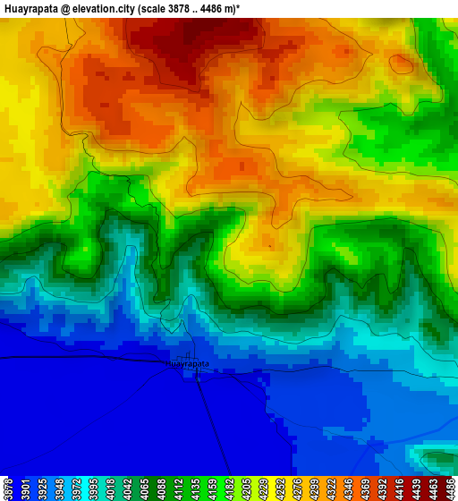
Below is the Elevation map of Huayrapata, which displays elevation range with different colors. Scale of the first map is from 3878 to 4486 m (12723 to 14718 ft) with average elevation of 4117.6 meters (=13509 ft) [note 1]
These maps also provides idea of topography and contour of this city, they are displayed at different zoom levels. More info about maps, scale and edge coordinates you can find below images.
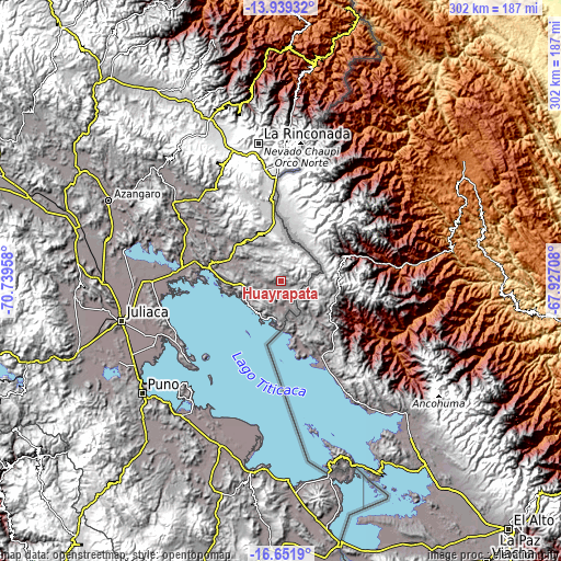
| \ | Map #1 | Topo.Map |
| Scale [m] | 3878..4486 m | × |
| Scale [ft] | 12723..14718 ft | × |
| Average | 4117.6 m = 13509 ft | × |
| Width | 9.43 km = 5.9 mi | 301.6 km = 187.4 mi |
| Height | 9.43 km = 5.9 mi | 301.6 km = 187.4 mi |
| ↑Max Latitude | -15.257608° | -13.93932° |
| Latitude at center | -15.3° | -15.3° |
| ↓Min Latitude | -15.342383° | -16.6519° |
| ← Min Longitude | -69.377275° | -70.73958° |
| Longitude center | -69.33333° | -69.33333° |
| →Max Longitude | -69.289385° | -67.92708° |
Nearby cities:
Cities around Huayrapata sort by population:
• Putina elevation 3821 m
22.3 km,  208°
208°
• Taquile 3911 m
64 km,  215°
215°
• Taraco 3821 m
67.9 km,  270°
270°
• Pusi 3924 m
66 km,  257°
257°
• Ayrampuni 3858 m
65.2 km,  295°
295°
• Capachica 3830 m
63.7 km,  234°
234°
• Inchupalla 3959 m
50.2 km,  311°
311°
• Vilque Chico 3862 m
38.7 km,  283°
283°
• Cojata 4347 m
31.7 km,  353°
353°
• Rosaspata 3933 m
23.4 km,  293°
293°
• Moho 4041 m
18.7 km,  252°
252°
• Conima 4151 m
18.3 km, 215°
Multilingual:
 En español:
Huayrapata elevación 4238 m.
 En France:
Huayrapata élévation 4238 m.
 Auf Deutsch:
Huayrapata höhe über dem Meeresspiegel ist 4238 m.

Sources and notes:
- [note 1] Map square and city borders are not equal. Map elevation data is calculated only from area inside that square.
- [src 1] Elevation data from geonames database provided with same terms of usage.
- [src 2] The elevation map of Huayrapata is generated using elevation data from NASA's 3 arcsec (90m) resolution SRTM data.
- [src 3] Base (background) map © OpenStreetMap contributors tiles are generated by Geofabrik and OpenTopoMap.
Copyright & License:
This Huayrapata Elevation Map is licensed under CC BY-SA. You may reuse any part from this page, if you give a proper credit by linking to this URL:
 More info on terms of use page.