Putina elevation
Putina (Puno, Moho), Peru elevation is 3821 meters and Putina elevation in feet is 12536 ft above sea level [src 1]. Putina is a populated place (feature code) with elevation that is 1500 meters (4921 ft) bigger than average city elevation in Peru.
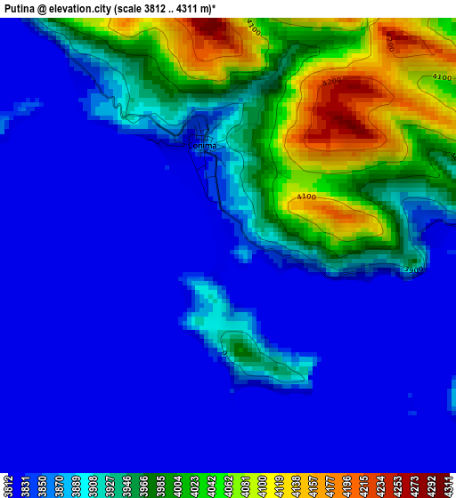
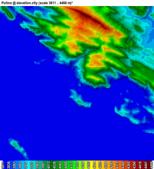
Below is the Elevation map of Putina, which displays elevation range with different colors. Scale of the first map is from 3812 to 4311 m (12507 to 14144 ft) with average elevation of 3898.1 meters (=12789 ft) [note 1]
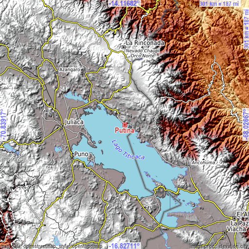
These maps also provides idea of topography and contour of this city, they are displayed at different zoom levels. More info about maps, scale and edge coordinates you can find below images.
| \ | Map #1 | Map #2 | Topo.Map |
| Scale [m] | 3812..4311 m | 3811..4466 m | × |
| Scale [ft] | 12507..14144 ft | 12503..14652 ft | × |
| Average | 3898.1 m = 12789 ft | 3906 m = 12815 ft | × |
| Width | 9.42 km = 5.9 mi | 18.84 km = 11.7 mi | 301.4 km = 187.3 mi |
| Height | 9.42 km = 5.9 mi | 18.84 km = 11.7 mi | 301.4 km = 187.3 mi |
| ↑Max Latitude | -15.434044° | -15.391679° | -14.11682° |
| Latitude at center | -15.4764° | -15.4764° | -15.4764° |
| ↓Min Latitude | -15.518748° | -15.561086° | -16.82711° |
| ← Min Longitude | -69.476865° | -69.520811° | -70.83917° |
| Longitude center | -69.43292° | -69.43292° | -69.43292° |
| →Max Longitude | -69.388975° | -69.345029° | -68.02667° |
Nearby cities:
Cities around Putina sort by population:
• Taquile elevation 3911 m
42 km,  219°
219°
• Inchupalla 3959 m
59.4 km,  333°
333°
• Huata 3878 m
59.3 km,  254°
254°
• Coata 3817 m
56.3 km,  259°
259°
• Pusi 3924 m
53.8 km,  275°
275°
• Cojata 4347 m
51.6 km,  7°
7°
• Capachica 3830 m
44.7 km, 246°
• Vilque Chico 3862 m
39.4 km,  317°
317°
• Rosaspata 3933 m
30.8 km,  339°
339°
• Huayrapata 4238 m
22.3 km,  28°
28°
• Moho 4041 m
15.8 km, 332°
• Conima 4151 m
4.8 km,  359°
359°
Multilingual:
 En español:
Putina elevación 3821 m.
 En France:
Putina élévation 3821 m.


Sources and notes:
- [note 1] Map square and city borders are not equal. Map elevation data is calculated only from area inside that square.
- [src 1] Elevation data from geonames database provided with same terms of usage.
- [src 2] The elevation map of Putina is generated using elevation data from NASA's 3 arcsec (90m) resolution SRTM data.
- [src 3] Base (background) map © OpenStreetMap contributors tiles are generated by Geofabrik and OpenTopoMap.
Copyright & License:
This Putina Elevation Map is licensed under CC BY-SA. You may reuse any part from this page, if you give a proper credit by linking to this URL:
 More info on terms of use page.