Inchupalla elevation
Inchupalla (Puno, Provincia de Huancané), Peru elevation is 3959 meters and Inchupalla elevation in feet is 12989 ft above sea level [src 1]. Inchupalla is a seat of a third-order administrative division (feature code) with elevation that is 1638 meters (5374 ft) bigger than average city elevation in Peru.
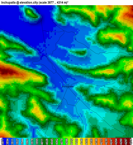
Below is the Elevation map of Inchupalla, which displays elevation range with different colors. Scale of the first map is from 3877 to 4314 m (12720 to 14154 ft) with average elevation of 3993.7 meters (=13103 ft) [note 1]
These maps also provides idea of topography and contour of this city, they are displayed at different zoom levels. More info about maps, scale and edge coordinates you can find below images.
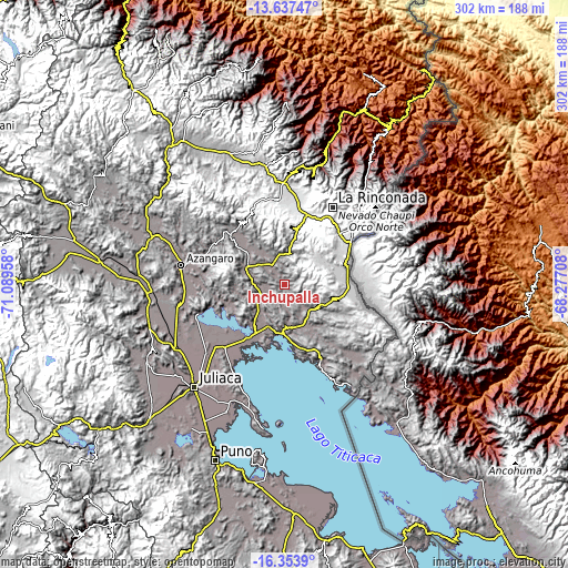
| \ | Map #1 | Topo.Map |
| Scale [m] | 3877..4314 m | × |
| Scale [ft] | 12720..14154 ft | × |
| Average | 3993.7 m = 13103 ft | × |
| Width | 9.44 km = 5.9 mi | 302 km = 187.7 mi |
| Height | 9.44 km = 5.9 mi | 302.1 km = 187.7 mi |
| ↑Max Latitude | -14.957548° | -13.63747° |
| Latitude at center | -15° | -15° |
| ↓Min Latitude | -15.042444° | -16.3539° |
| ← Min Longitude | -69.727275° | -71.08958° |
| Longitude center | -69.68333° | -69.68333° |
| →Max Longitude | -69.639385° | -68.27708° |
Nearby cities:
Cities around Inchupalla sort by population:
• La Rinconada elevation 5022 m
48.3 km,  31°
31°
• Arapa 3916 m
48.8 km,  252°
252°
• Taraco 3821 m
45.1 km,  222°
222°
• Moho 4041 m
43.6 km,  153°
153°
• Muñani 3927 m
38.7 km,  312°
312°
• Ananea 4690 m
36.3 km,  23°
23°
• Chupa 3894 m
34.1 km, 250°
• Cojata 4347 m
34.1 km,  93°
93°
• Rosaspata 3933 m
29 km, 146°
• Vilque Chico 3862 m
24.1 km,  180°
180°
• Ayrampuni 3858 m
22.2 km,  255°
255°
• Putina 3863 m
21.8 km,  295°
295°
Multilingual:
 En español:
Inchupalla elevación 3959 m.
 En France:
Inchupalla élévation 3959 m.
 Auf Deutsch:
Inchupalla höhe über dem Meeresspiegel ist 3959 m.

Sources and notes:
- [note 1] Map square and city borders are not equal. Map elevation data is calculated only from area inside that square.
- [src 1] Elevation data from geonames database provided with same terms of usage.
- [src 2] The elevation map of Inchupalla is generated using elevation data from NASA's 3 arcsec (90m) resolution SRTM data.
- [src 3] Base (background) map © OpenStreetMap contributors tiles are generated by Geofabrik and OpenTopoMap.
Copyright & License:
This Inchupalla Elevation Map is licensed under CC BY-SA. You may reuse any part from this page, if you give a proper credit by linking to this URL:
 More info on terms of use page.