Ananea elevation
Ananea (Puno, San Antonio De Putina), Peru elevation is 4690 meters and Ananea elevation in feet is 15387 ft above sea level [src 1]. Ananea is a seat of a third-order administrative division (feature code) with elevation that is 2369 meters (7772 ft) bigger than average city elevation in Peru.
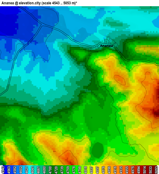
Below is the Elevation map of Ananea, which displays elevation range with different colors. Scale of the first map is from 4543 to 5053 m (14905 to 16578 ft) with average elevation of 4726.7 meters (=15508 ft) [note 1]
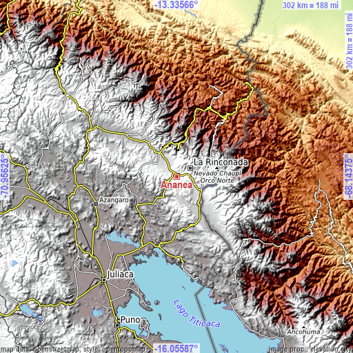
These maps also provides idea of topography and contour of this city, they are displayed at different zoom levels. More info about maps, scale and edge coordinates you can find below images.
| \ | Map #1 | Topo.Map |
| Scale [m] | 4543..5053 m | × |
| Scale [ft] | 14905..16578 ft | × |
| Average | 4726.7 m = 15508 ft | × |
| Width | 9.45 km = 5.9 mi | 302.5 km = 188 mi |
| Height | 9.45 km = 5.9 mi | 302.5 km = 188 mi |
| ↑Max Latitude | -14.657489° | -13.33566° |
| Latitude at center | -14.7° | -14.7° |
| ↓Min Latitude | -14.742503° | -16.05587° |
| ← Min Longitude | -69.593945° | -70.95625° |
| Longitude center | -69.55° | -69.55° |
| →Max Longitude | -69.506055° | -68.14375° |
Nearby cities:
Cities around Ananea sort by population:
• La Rinconada elevation 5022 m
13.5 km,  55°
55°
• Rosaspata 3933 m
57.5 km,  178°
178°
• Sandia 2907 m
53.4 km,  13°
13°
• Ayrampuni 3858 m
52.9 km,  222°
222°
• Muñani 3927 m
43.6 km,  260°
260°
• Putina 3863 m
41.7 km,  234°
234°
• Cojata 4347 m
40.3 km,  150°
150°
• Patambuco 3594 m
38.6 km,  348°
348°
• Quiaca 2982 m
36.6 km,  35°
35°
• Inchupalla 3959 m
36.3 km,  203°
203°
• Sina 3472 m
36.3 km,  52°
52°
• Cuyocuyo 3427 m
25.5 km,  3°
3°
Multilingual:
 En español:
Ananea elevación 4690 m.
 En France:
Ananea élévation 4690 m.


Sources and notes:
- [note 1] Map square and city borders are not equal. Map elevation data is calculated only from area inside that square.
- [src 1] Elevation data from geonames database provided with same terms of usage.
- [src 2] The elevation map of Ananea is generated using elevation data from NASA's 3 arcsec (90m) resolution SRTM data.
- [src 3] Base (background) map © OpenStreetMap contributors tiles are generated by Geofabrik and OpenTopoMap.
Copyright & License:
This Ananea Elevation Map is licensed under CC BY-SA. You may reuse any part from this page, if you give a proper credit by linking to this URL:
 More info on terms of use page.