Lluta elevation
Lluta (Arequipa, Provincia de Caylloma), Peru elevation is 3023 meters and Lluta elevation in feet is 9918 ft above sea level [src 1]. Lluta is a seat of a third-order administrative division (feature code) with elevation that is 702 meters (2303 ft) bigger than average city elevation in Peru.
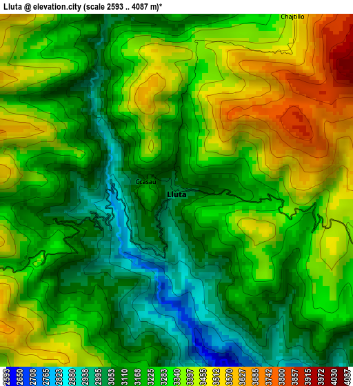
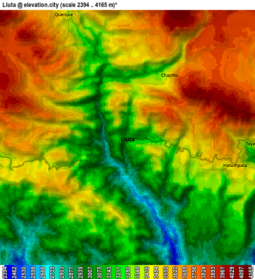
Below is the Elevation map of Lluta, which displays elevation range with different colors. Scale of the first map is from 2593 to 4087 m (8507 to 13409 ft) with average elevation of 3265.5 meters (=10714 ft) [note 1]
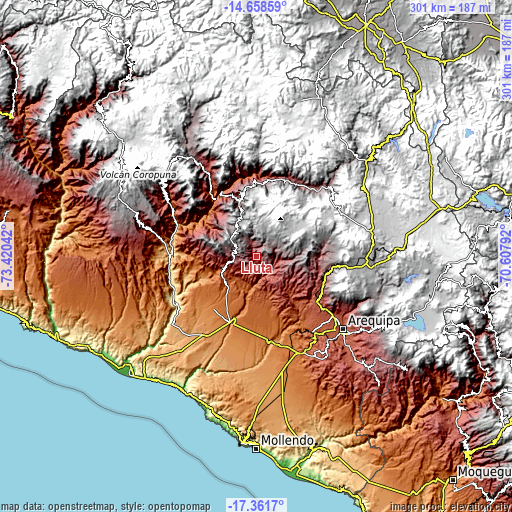
These maps also provides idea of topography and contour of this city, they are displayed at different zoom levels. More info about maps, scale and edge coordinates you can find below images.
| \ | Map #1 | Map #2 | Topo.Map |
| Scale [m] | 2593..4087 m | 2394..4165 m | × |
| Scale [ft] | 8507..13409 ft | 7854..13665 ft | × |
| Average | 3265.5 m = 10714 ft | 3377.2 m = 11080 ft | × |
| Width | 9.39 km = 5.8 mi | 18.79 km = 11.7 mi | 300.6 km = 186.8 mi |
| Height | 9.39 km = 5.8 mi | 18.79 km = 11.7 mi | 300.6 km = 186.8 mi |
| ↑Max Latitude | -15.972476° | -15.930222° | -14.65859° |
| Latitude at center | -16.01472° | -16.01472° | -16.01472° |
| ↓Min Latitude | -16.056955° | -16.099182° | -17.3617° |
| ← Min Longitude | -72.058115° | -72.102061° | -73.42042° |
| Longitude center | -72.01417° | -72.01417° | -72.01417° |
| →Max Longitude | -71.970225° | -71.926279° | -70.60792° |
Nearby cities:
Cities around Lluta sort by population:
• Yura elevation 2598 m
44.4 km,  126°
126°
• Aplao 648 m
51.7 km,  262°
262°
• Achoma 3488 m
51.7 km,  40°
40°
• Lari 3356 m
50.9 km,  31°
31°
• Choco 2456 m
50.4 km,  345°
345°
• Madrigal 3279 m
50.3 km, 25°
• Huancarqui 603 m
49.8 km, 259°
• Tapay 2989 m
49.2 km,  9°
9°
• Maca 3276 m
49 km, 32°
• Ayo 1983 m
46.3 km,  323°
323°
• Cabanaconde 3303 m
43.9 km,  4°
4°
• Huambo 3312 m
33.1 km,  342°
342°
Multilingual:
 En español:
Lluta elevación 3023 m.
 En France:
Lluta élévation 3023 m.


Sources and notes:
- [note 1] Map square and city borders are not equal. Map elevation data is calculated only from area inside that square.
- [src 1] Elevation data from geonames database provided with same terms of usage.
- [src 2] The elevation map of Lluta is generated using elevation data from NASA's 3 arcsec (90m) resolution SRTM data.
- [src 3] Base (background) map © OpenStreetMap contributors tiles are generated by Geofabrik and OpenTopoMap.
Copyright & License:
This Lluta Elevation Map is licensed under CC BY-SA. You may reuse any part from this page, if you give a proper credit by linking to this URL:
 More info on terms of use page.