Aplao elevation
Aplao (Arequipa, Provincia de Castilla), Peru elevation is 648 meters and Aplao elevation in feet is 2126 ft above sea level [src 1]. Aplao is a seat of a third-order administrative division (feature code) with elevation that is 1673 meters (5489 ft) smaller than average city elevation in Peru.
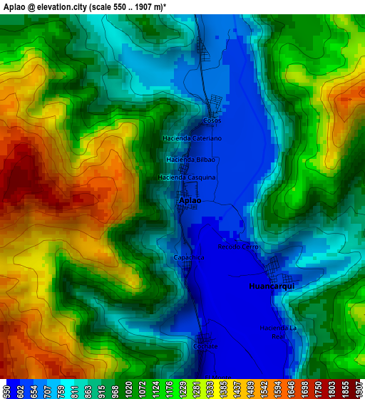
Below is the Elevation map of Aplao, which displays elevation range with different colors. Scale of the first map is from 550 to 1907 m (1804 to 6257 ft) with average elevation of 1024.7 meters (=3362 ft) [note 1]
These maps also provides idea of topography and contour of this city, they are displayed at different zoom levels. More info about maps, scale and edge coordinates you can find below images.
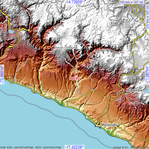
| \ | Map #1 | Topo.Map |
| Scale [m] | 550..1907 m | × |
| Scale [ft] | 1804..6257 ft | × |
| Average | 1024.7 m = 3362 ft | × |
| Width | 9.39 km = 5.8 mi | 300.5 km = 186.7 mi |
| Height | 9.39 km = 5.8 mi | 300.5 km = 186.7 mi |
| ↑Max Latitude | -16.033599° | -14.72009° |
| Latitude at center | -16.07583° | -16.07583° |
| ↓Min Latitude | -16.118052° | -17.42238° |
| ← Min Longitude | -72.537835° | -73.90014° |
| Longitude center | -72.49389° | -72.49389° |
| →Max Longitude | -72.449945° | -71.08764° |
Nearby cities:
Cities around Aplao sort by population:
• Lluta elevation 3023 m
51.7 km,  82°
82°
• Huambo 3312 m
56.4 km,  47°
47°
• Yanaquihua 3008 m
52.9 km,  309°
309°
• Andaray 3035 m
50 km, 308°
• Ayo 1983 m
49.7 km,  28°
28°
• Viraco 3215 m
46.7 km,  355°
355°
• Pampacolca 2918 m
41.2 km,  347°
347°
• Uñon 2773 m
39.1 km,  10°
10°
• Chuquibamba 2926 m
31.5 km,  327°
327°
• Iray 2403 m
28.2 km, 330°
• Corire 434 m
16.6 km,  171°
171°
• Huancarqui 603 m
3.2 km,  134°
134°
Multilingual:
 En español:
Aplao elevación 648 m.
 En France:
Aplao élévation 648 m.


Sources and notes:
- [note 1] Map square and city borders are not equal. Map elevation data is calculated only from area inside that square.
- [src 1] Elevation data from geonames database provided with same terms of usage.
- [src 2] The elevation map of Aplao is generated using elevation data from NASA's 3 arcsec (90m) resolution SRTM data.
- [src 3] Base (background) map © OpenStreetMap contributors tiles are generated by Geofabrik and OpenTopoMap.
Copyright & License:
This Aplao Elevation Map is licensed under CC BY-SA. You may reuse any part from this page, if you give a proper credit by linking to this URL:
 More info on terms of use page.