Yura elevation
Yura (Arequipa, Provincia de Arequipa), Peru elevation is 2598 meters and Yura elevation in feet is 8524 ft above sea level [src 1]. Yura is a seat of a third-order administrative division (feature code) with elevation that is 277 meters (909 ft) bigger than average city elevation in Peru.
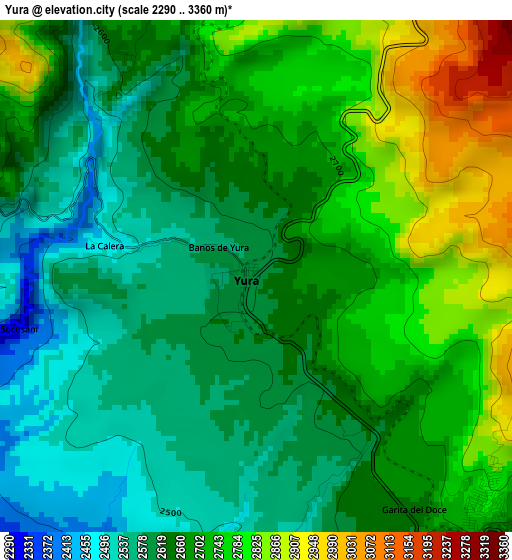
Below is the Elevation map of Yura, which displays elevation range with different colors. Scale of the first map is from 2290 to 3360 m (7513 to 11024 ft) with average elevation of 2674.3 meters (=8774 ft) [note 1]
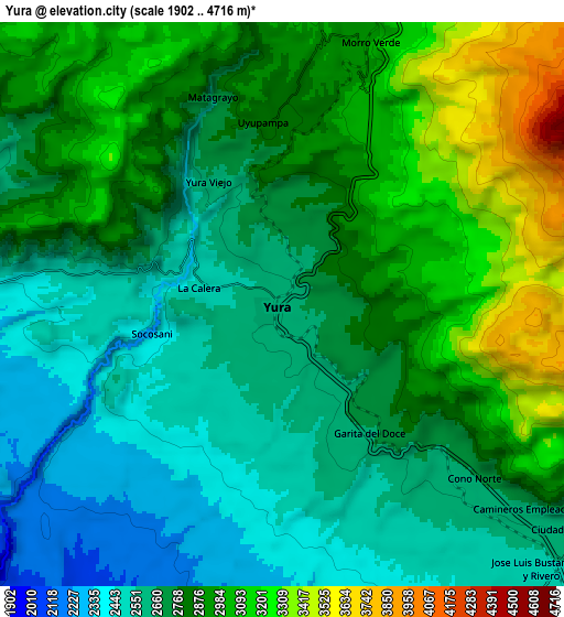
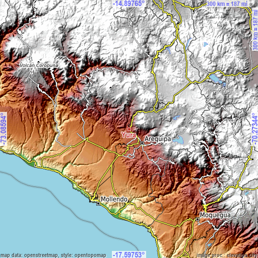
These maps also provides idea of topography and contour of this city, they are displayed at different zoom levels. More info about maps, scale and edge coordinates you can find below images.
| \ | Map #1 | Map #2 | Topo.Map |
| Scale [m] | 2290..3360 m | 1902..4716 m | × |
| Scale [ft] | 7513..11024 ft | 6240..15472 ft | × |
| Average | 2674.3 m = 8774 ft | 2804.6 m = 9201 ft | × |
| Width | 9.38 km = 5.8 mi | 18.76 km = 11.7 mi | 300.2 km = 186.5 mi |
| Height | 9.38 km = 5.8 mi | 18.76 km = 11.7 mi | 300.2 km = 186.5 mi |
| ↑Max Latitude | -16.210036° | -16.167833° | -14.89765° |
| Latitude at center | -16.25223° | -16.25223° | -16.25223° |
| ↓Min Latitude | -16.294415° | -16.33659° | -17.59753° |
| ← Min Longitude | -71.723635° | -71.767581° | -73.08594° |
| Longitude center | -71.67969° | -71.67969° | -71.67969° |
| →Max Longitude | -71.635745° | -71.591799° | -70.27344° |
Nearby cities:
Cities around Yura sort by population:
• Arequipa elevation 2355 m
22.5 km,  136°
136°
• Lluta 3023 m
44.4 km,  306°
306°
• Pucara 4352 m
38.3 km,  37°
37°
• Pocsi 3055 m
42.8 km,  133°
133°
• Quequeña 2567 m
41.8 km, 144°
• Yarabamba 2474 m
39.3 km,  146°
146°
• Chiguata 2947 m
34.1 km,  118°
118°
• Characato 2460 m
31.7 km, 138°
• Sabandia 2438 m
30.6 km, 141°
• Socabaya 2329 m
29.2 km, 146°
• Tiabaya 2176 m
24 km,  156°
156°
• Uchumayo 1972 m
19.2 km,  177°
177°
Multilingual:
 En español:
Yura elevación 2598 m.
 En France:
Yura élévation 2598 m.


Sources and notes:
- [note 1] Map square and city borders are not equal. Map elevation data is calculated only from area inside that square.
- [src 1] Elevation data from geonames database provided with same terms of usage.
- [src 2] The elevation map of Yura is generated using elevation data from NASA's 3 arcsec (90m) resolution SRTM data.
- [src 3] Base (background) map © OpenStreetMap contributors tiles are generated by Geofabrik and OpenTopoMap.
Copyright & License:
This Yura Elevation Map is licensed under CC BY-SA. You may reuse any part from this page, if you give a proper credit by linking to this URL:
 More info on terms of use page.