Surcubamba elevation
Surcubamba (Huancavelica, Provincia de Tayacaja), Peru elevation is 2195 meters and Surcubamba elevation in feet is 7201 ft above sea level [src 1]. Surcubamba is a seat of a third-order administrative division (feature code) with elevation that is 126 meters (413 ft) smaller than average city elevation in Peru.
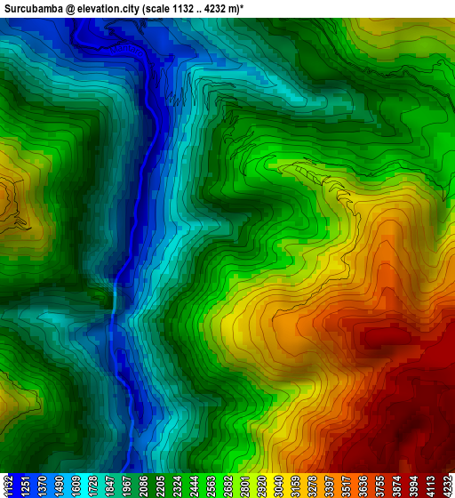
Below is the Elevation map of Surcubamba, which displays elevation range with different colors. Scale of the first map is from 1132 to 4232 m (3714 to 13885 ft) with average elevation of 2424.8 meters (=7955 ft) [note 1]
These maps also provides idea of topography and contour of this city, they are displayed at different zoom levels. More info about maps, scale and edge coordinates you can find below images.
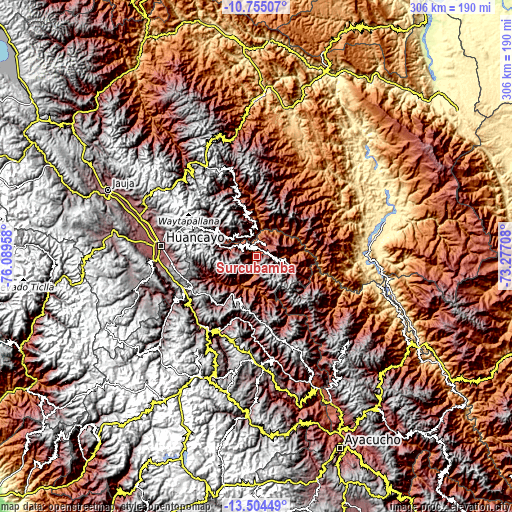
| \ | Map #1 | Topo.Map |
| Scale [m] | 1132..4232 m | × |
| Scale [ft] | 3714..13885 ft | × |
| Average | 2424.8 m = 7955 ft | × |
| Width | 9.55 km = 5.9 mi | 305.7 km = 190 mi |
| Height | 9.55 km = 5.9 mi | 305.7 km = 190 mi |
| ↑Max Latitude | -12.090363° | -10.75507° |
| Latitude at center | -12.13333° | -12.13333° |
| ↓Min Latitude | -12.17629° | -13.50449° |
| ← Min Longitude | -74.727275° | -76.08958° |
| Longitude center | -74.68333° | -74.68333° |
| →Max Longitude | -74.639385° | -73.27708° |
Nearby cities:
Cities around Surcubamba sort by population:
• Pampas elevation 3252 m
35.3 km,  214°
214°
• Sapallanga 3267 m
54.4 km,  268°
268°
• Pilchaca 3529 m
54.1 km,  236°
236°
• Cullhuas 3750 m
53.7 km,  258°
258°
• Izcuchaca 3415 m
53.2 km,  222°
222°
• Cuenca 3060 m
50.6 km,  228°
228°
• Paucarbamba 3248 m
48.5 km,  162°
162°
• Pazos 3947 m
47.6 km,  251°
251°
• Andamarca 2485 m
46.5 km,  343°
343°
• Huaribamba 3147 m
32.6 km, 242°
• Colcabamba 3557 m
29.7 km,  183°
183°
• Salcabamba 3143 m
13.2 km, 235°
Multilingual:
 En español:
Surcubamba elevación 2195 m.
 En France:
Surcubamba élévation 2195 m.
 Auf Deutsch:
Surcubamba höhe über dem Meeresspiegel ist 2195 m.

Sources and notes:
- [note 1] Map square and city borders are not equal. Map elevation data is calculated only from area inside that square.
- [src 1] Elevation data from geonames database provided with same terms of usage.
- [src 2] The elevation map of Surcubamba is generated using elevation data from NASA's 3 arcsec (90m) resolution SRTM data.
- [src 3] Base (background) map © OpenStreetMap contributors tiles are generated by Geofabrik and OpenTopoMap.
Copyright & License:
This Surcubamba Elevation Map is licensed under CC BY-SA. You may reuse any part from this page, if you give a proper credit by linking to this URL:
 More info on terms of use page.