Sapallanga elevation
Sapallanga (Junin, Provincia de Huancayo), Peru elevation is 3267 meters and Sapallanga elevation in feet is 10719 ft above sea level [src 1]. Sapallanga is a seat of a third-order administrative division (feature code) with elevation that is 946 meters (3104 ft) bigger than average city elevation in Peru.
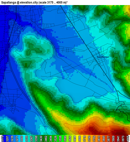
Below is the Elevation map of Sapallanga, which displays elevation range with different colors. Scale of the first map is from 3175 to 4005 m (10417 to 13140 ft) with average elevation of 3355 meters (=11007 ft) [note 1]
These maps also provides idea of topography and contour of this city, they are displayed at different zoom levels. More info about maps, scale and edge coordinates you can find below images.
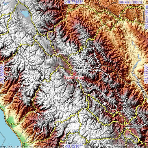
| \ | Map #1 | Topo.Map |
| Scale [m] | 3175..4005 m | × |
| Scale [ft] | 10417..13140 ft | × |
| Average | 3355 m = 11007 ft | × |
| Width | 9.55 km = 5.9 mi | 305.7 km = 190 mi |
| Height | 9.55 km = 5.9 mi | 305.7 km = 190 mi |
| ↑Max Latitude | -12.107036° | -10.77183° |
| Latitude at center | -12.15° | -12.15° |
| ↓Min Latitude | -12.192957° | -13.52107° |
| ← Min Longitude | -75.227275° | -76.58958° |
| Longitude center | -75.18333° | -75.18333° |
| →Max Longitude | -75.139385° | -73.77708° |
Nearby cities:
Cities around Sapallanga sort by population:
• Huancayo elevation 3263 m
9.7 km,  346°
346°
• Chupaca 3254 m
14.3 km,  310°
310°
• Pilcomay 3205 m
13.5 km,  327°
327°
• Sicaya 3252 m
16.9 km,  320°
320°
• Huayucachi 3170 m
5.7 km,  288°
288°
• Ahuac 3581 m
20.4 km,  297°
297°
• Chicche 3687 m
19.9 km,  213°
213°
• Colca 4176 m
17.1 km,  192°
192°
• Pazos 3947 m
15.8 km,  145°
145°
• El Tambo 3249 m
9.9 km,  338°
338°
• Cullhuas 3750 m
9.4 km,  168°
168°
• Huacrapuquio 3229 m
5.2 km,  224°
224°
Multilingual:
 En español:
Sapallanga elevación 3267 m.
 En France:
Sapallanga élévation 3267 m.
 Auf Deutsch:
Sapallanga höhe über dem Meeresspiegel ist 3267 m.

Sources and notes:
- [note 1] Map square and city borders are not equal. Map elevation data is calculated only from area inside that square.
- [src 1] Elevation data from geonames database provided with same terms of usage.
- [src 2] The elevation map of Sapallanga is generated using elevation data from NASA's 3 arcsec (90m) resolution SRTM data.
- [src 3] Base (background) map © OpenStreetMap contributors tiles are generated by Geofabrik and OpenTopoMap.
Copyright & License:
This Sapallanga Elevation Map is licensed under CC BY-SA. You may reuse any part from this page, if you give a proper credit by linking to this URL:
 More info on terms of use page.