Paucarbamba elevation
Paucarbamba (Huancavelica, Provincia de Churcampa), Peru elevation is 3248 meters and Paucarbamba elevation in feet is 10656 ft above sea level [src 1]. Paucarbamba is a seat of a third-order administrative division (feature code) with elevation that is 927 meters (3041 ft) bigger than average city elevation in Peru.
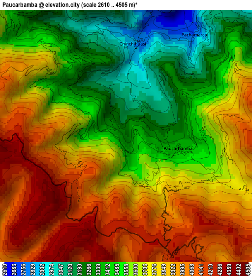
Below is the Elevation map of Paucarbamba, which displays elevation range with different colors. Scale of the first map is from 2610 to 4505 m (8563 to 14780 ft) with average elevation of 3689.5 meters (=12105 ft) [note 1]
These maps also provides idea of topography and contour of this city, they are displayed at different zoom levels. More info about maps, scale and edge coordinates you can find below images.
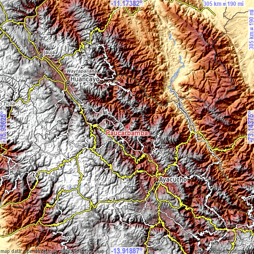
| \ | Map #1 | Topo.Map |
| Scale [m] | 2610..4505 m | × |
| Scale [ft] | 8563..14780 ft | × |
| Average | 3689.5 m = 12105 ft | × |
| Width | 9.54 km = 5.9 mi | 305.2 km = 189.6 mi |
| Height | 9.54 km = 5.9 mi | 305.2 km = 189.6 mi |
| ↑Max Latitude | -12.507101° | -11.17382° |
| Latitude at center | -12.55° | -12.55° |
| ↓Min Latitude | -12.592892° | -13.91887° |
| ← Min Longitude | -74.593945° | -75.95625° |
| Longitude center | -74.55° | -74.55° |
| →Max Longitude | -74.506055° | -73.14375° |
Nearby cities:
Cities around Paucarbamba sort by population:
• Pampas elevation 3252 m
38.5 km,  296°
296°
• Anchonga 3686 m
40.5 km,  203°
203°
• Caja 3486 m
38.1 km,  166°
166°
• Acoria 3358 m
36.9 km,  258°
258°
• Callanmarca 3619 m
36.4 km,  194°
194°
• Acobamba 3350 m
35.3 km,  182°
182°
• Pomacocha 3501 m
33.6 km, 173°
• Mayocc 2717 m
30.6 km,  147°
147°
• Colcabamba 3557 m
23.3 km,  315°
315°
• Churcampa 3846 m
23.3 km,  135°
135°
• Locroja 3672 m
19.5 km, 139°
• La Esmeralda 3427 m
10.7 km,  210°
210°
Multilingual:
 En español:
Paucarbamba elevación 3248 m.
 En France:
Paucarbamba élévation 3248 m.
 Auf Deutsch:
Paucarbamba höhe über dem Meeresspiegel ist 3248 m.

Sources and notes:
- [note 1] Map square and city borders are not equal. Map elevation data is calculated only from area inside that square.
- [src 1] Elevation data from geonames database provided with same terms of usage.
- [src 2] The elevation map of Paucarbamba is generated using elevation data from NASA's 3 arcsec (90m) resolution SRTM data.
- [src 3] Base (background) map © OpenStreetMap contributors tiles are generated by Geofabrik and OpenTopoMap.
Copyright & License:
This Paucarbamba Elevation Map is licensed under CC BY-SA. You may reuse any part from this page, if you give a proper credit by linking to this URL:
 More info on terms of use page.