Acoria elevation
Acoria (Huancavelica, Provincia de Huancavelica), Peru elevation is 3358 meters and Acoria elevation in feet is 11017 ft above sea level [src 1]. Acoria is a seat of a third-order administrative division (feature code) with elevation that is 1037 meters (3402 ft) bigger than average city elevation in Peru.
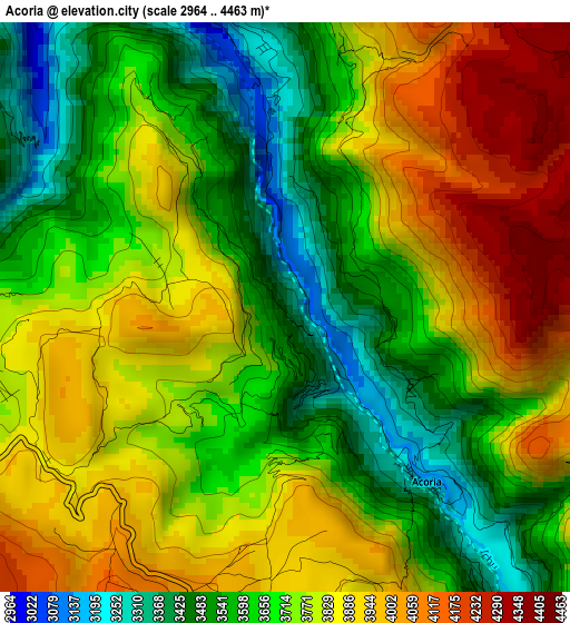
Below is the Elevation map of Acoria, which displays elevation range with different colors. Scale of the first map is from 2964 to 4463 m (9724 to 14642 ft) with average elevation of 3739 meters (=12267 ft) [note 1]
These maps also provides idea of topography and contour of this city, they are displayed at different zoom levels. More info about maps, scale and edge coordinates you can find below images.
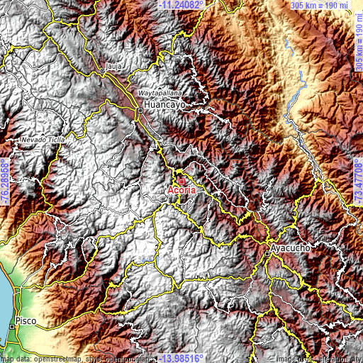
| \ | Map #1 | Topo.Map |
| Scale [m] | 2964..4463 m | × |
| Scale [ft] | 9724..14642 ft | × |
| Average | 3739 m = 12267 ft | × |
| Width | 9.54 km = 5.9 mi | 305.1 km = 189.6 mi |
| Height | 9.54 km = 5.9 mi | 305.2 km = 189.6 mi |
| ↑Max Latitude | -12.573782° | -11.24082° |
| Latitude at center | -12.61667° | -12.61667° |
| ↓Min Latitude | -12.659551° | -13.98516° |
| ← Min Longitude | -74.927275° | -76.28958° |
| Longitude center | -74.88333° | -74.88333° |
| →Max Longitude | -74.839385° | -73.47708° |
Nearby cities:
Cities around Acoria sort by population:
• Huancavelica elevation 3704 m
20.8 km,  207°
207°
• Pampas 3252 m
24.7 km,  4°
4°
• Huayllahuara 3511 m
39.1 km,  308°
308°
• Callanmarca 3619 m
38.8 km,  135°
135°
• Paucarbamba 3248 m
36.9 km,  78°
78°
• Vilca 3217 m
35.8 km,  294°
294°
• Anchonga 3686 m
35.7 km,  146°
146°
• Pilchaca 3529 m
33.7 km,  315°
315°
• Colcabamba 3557 m
31.2 km,  39°
39°
• La Esmeralda 3427 m
30.8 km,  93°
93°
• Cuenca 3060 m
26.1 km, 321°
• Izcuchaca 3415 m
20.7 km, 315°
Multilingual:
 En español:
Acoria elevación 3358 m.
 En France:
Acoria élévation 3358 m.


Sources and notes:
- [note 1] Map square and city borders are not equal. Map elevation data is calculated only from area inside that square.
- [src 1] Elevation data from geonames database provided with same terms of usage.
- [src 2] The elevation map of Acoria is generated using elevation data from NASA's 3 arcsec (90m) resolution SRTM data.
- [src 3] Base (background) map © OpenStreetMap contributors tiles are generated by Geofabrik and OpenTopoMap.
Copyright & License:
This Acoria Elevation Map is licensed under CC BY-SA. You may reuse any part from this page, if you give a proper credit by linking to this URL:
 More info on terms of use page.