Yanacancha elevation
Yanacancha (Junin, Provincia de Chupaca), Peru elevation is 3967 meters and Yanacancha elevation in feet is 13015 ft above sea level [src 1]. Yanacancha is a seat of a third-order administrative division (feature code) with elevation that is 1646 meters (5400 ft) bigger than average city elevation in Peru.
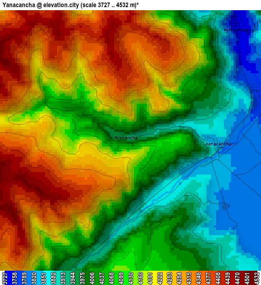
Below is the Elevation map of Yanacancha, which displays elevation range with different colors. Scale of the first map is from 3727 to 4532 m (12228 to 14869 ft) with average elevation of 4123.2 meters (=13528 ft) [note 1]
These maps also provides idea of topography and contour of this city, they are displayed at different zoom levels. More info about maps, scale and edge coordinates you can find below images.
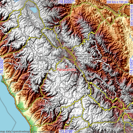
| \ | Map #1 | Topo.Map |
| Scale [m] | 3727..4532 m | × |
| Scale [ft] | 12228..14869 ft | × |
| Average | 4123.2 m = 13528 ft | × |
| Width | 9.55 km = 5.9 mi | 305.6 km = 189.9 mi |
| Height | 9.55 km = 5.9 mi | 305.7 km = 190 mi |
| ↑Max Latitude | -12.157044° | -10.82207° |
| Latitude at center | -12.2° | -12.2° |
| ↓Min Latitude | -12.242949° | -13.5708° |
| ← Min Longitude | -75.460615° | -76.82292° |
| Longitude center | -75.41667° | -75.41667° |
| →Max Longitude | -75.372725° | -74.01042° |
Nearby cities:
Cities around Yanacancha sort by population:
• Chupaca elevation 3254 m
20.7 km,  44°
44°
• Pilcomay 3205 m
24.9 km,  46°
46°
• Sicaya 3252 m
23.5 km, 38°
• Huayucachi 3170 m
21.3 km,  69°
69°
• Sapallanga 3267 m
26 km,  77°
77°
• Chacapampa 3459 m
24.6 km,  132°
132°
• Colca 4176 m
24.4 km,  117°
117°
• Huacrapuquio 3229 m
21.8 km,  85°
85°
• Chambara 3548 m
20.7 km,  10°
10°
• Chicche 3687 m
18.3 km, 127°
• Ahuac 3581 m
16.5 km,  26°
26°
• Jarpa 4184 m
10.7 km,  329°
329°
Multilingual:
 En español:
Yanacancha elevación 3967 m.
 En France:
Yanacancha élévation 3967 m.
 Auf Deutsch:
Yanacancha höhe über dem Meeresspiegel ist 3967 m.

Sources and notes:
- [note 1] Map square and city borders are not equal. Map elevation data is calculated only from area inside that square.
- [src 1] Elevation data from geonames database provided with same terms of usage.
- [src 2] The elevation map of Yanacancha is generated using elevation data from NASA's 3 arcsec (90m) resolution SRTM data.
- [src 3] Base (background) map © OpenStreetMap contributors tiles are generated by Geofabrik and OpenTopoMap.
Copyright & License:
This Yanacancha Elevation Map is licensed under CC BY-SA. You may reuse any part from this page, if you give a proper credit by linking to this URL:
 More info on terms of use page.